


ABSTRACT
In the present study, the groundwater prospect of Sinnar area has been delineated using remotely sensing data, base map of Geological Survey of India(GSI), ground truth data, and geographic information system. Based on these integrated studies, it has been noticed that the lithology of the area mainly consist vesicular/weathered basalt, massive and hard compact basalt belonging to cretaceous to early Eocene period. Based on hydro-geomorphological, geological and lineament mapping the Sinnar area can be qualitatively categorized into three groundwater potential units, viz. good, moderate and poor . The high prospect zones are alluvial plains and valley fills mainly influenced by quaternary formations with yield expectation between 15 to 180 lpm. The moderate zone is mainly consisting of weathered and fractured aquifer material with expected yield of water between 30 to180 lpm. The low potential zones mainly comprises of massive and hard rocky surface with expected discharge below 50 lpm.
Keywords: Groundwater, Potential, Lineaments, Geology, Basalt.
INTRODUCTION
Groundwater is a precious gift of nature. Remote sensing tools and methods are increasingly becoming popular for mapping land features with the advent of improved satellites sensors; where images can be acquired with fine resolution and image interpretation is faster and less expensive than the ground survey. Remote sensing techniques provide us an opportunity to study the surface resources of the Earth in a systematic repetitive manner.
Remote sensing and geographical information system(GIS) is a most powerful tool of delineation of groundwater potential for occurrence and distribution of groundwater regime. Many authors has worked upon the application of Remote Sensing and GIS techniques in groundwater studies (Krishnamurthy and Srinivas 1995; Krishnamurhty et al. 1996; Saraf and Chaudhary 1998; Khan and Mohrana 2002; Pietronio & Prowse. 2002; Hoffmann, 2005; Jaiswal et al. 2005; Jha and Chaudhary 2007; Hoffmann and Sander 2007). It will support in the quantification of hydrologic parameter in data collection and transmission to facilitate rapid analysis of various facet of water resources.
LOCATION OF STUDY AREA
The Sinnar study area confined between Longitude 73°52'55'E to 74°12'54'E latitude 19°42'23'N to 19°56'30'N. The study area belongs to Nasik district, Maharashtra covered an about 566 Sq.km. area.
Geology of the Study Area
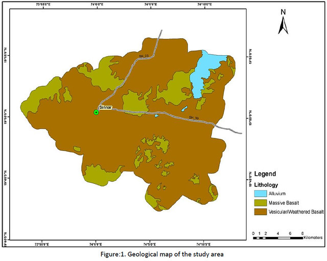
Geologically, the entire study area is covered by Deccan basalt formations( Fig-1) comprising nearly horizontal lava flows. These flows have been considered to be a result of fissure type of lava eruption during late Cretaceous to early Eocene period. The types of basalt occurring in the area are vesicular/weathered basalt and massive basalt, in the present study geological mapping is done using IRS-P6, LISS-IV image with the helpof image interpretation. Keys Basalts are showing bluish tone with coarse texture. Basalts occurring in and around the study area exhibit both vesicular and massive forms. The massive basalt units are fine grained, dense and compact, they are dark in colour. The vesicular type of basalts is highly weathered.
Geological Structure
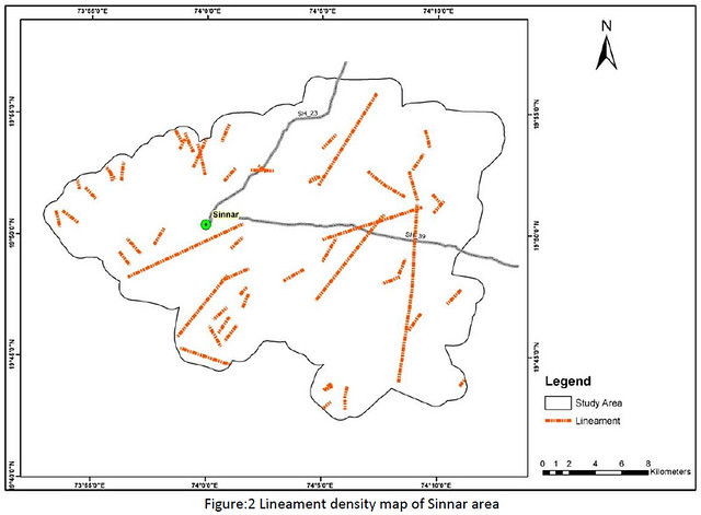
The Sinnar area is traversed by various directional fractures / lineaments and most of them are in NW – SE, NESW, ENE – WSW and E – W directions( Fig-2). Lineaments look as narrow linear features with dark tone due to high moisture content and look red due to presence of vegetation. Presence of lineaments in a geomorphic unit increases the prospects of groundwater occurrence in Sinnar area Nasik district Maharashtra.
The micro-lineaments are found to be better conduits of groundwater. Presence of lineaments in a geomorphic unit increases the prospects of groundwater (Murthy and Jayram, 1996; Thorat and Sable, 1990, Muley et.al, 2010).
Groundwater Potential Mapping
Geological and remote sensing data has been utilized for delineation of groundwater potential zones. A strong mutual correlation exists between geological variables and hydrological characteristics. Such relationship can be applied to both surface and groundwater regime. Thus the linking of geological parameters with hydrological characteristics of the area provides a simple way to understand the hydrogeological andgroundwater potential behaviour of the area.
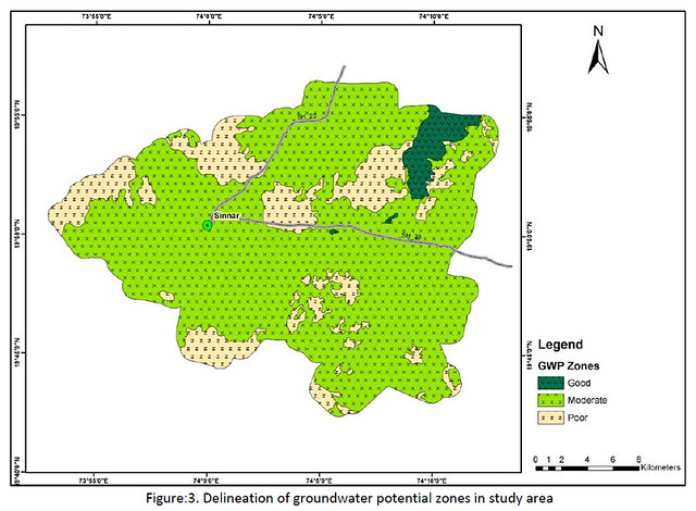
The groundwater potentiality of the area has been assessed through integration of the hydrogeology, lineament, slope and aquifer thickness. The groundwater potential zones map (Fig-3) generated through the base map and remote sensing was verified with the yield data to ascertain the validity of the potential zones. The verification showed that the groundwater potential zones demarcated through the map are in tune with the bore well yield data. Basically three groundwater potential units have been demarcated such as good,moderate and poor.
On the basis of hydrogeological and lithological characteristics, three categories of groundwater prospect zones: high, moderate and low are delineated. The high prospect zones are alluvial plains and valley fills mainly influenced by quaternary formations with yield expectation between 15 to 180 lpm. The moderate zone has vesicular/weathered covered in addition to weathered and fractured aquifer material with expected yield of water between 30 to 180lpm. The low potential zones mainly comprise massive and hard rocky surface withexpected discharge below 50 lpm.
Thus, the above study has clearly demonstrated the capabilities of geological studies and remote sensing in demarcation of the different groundwater potential zones in the study areas.
CONCLUSION
The groundwater potential units revels and give an idea about development and management plan of groundwater recourses. The three type of groundwater potential units has been observed such that good, moderate and poor potential zones. These units have been demarcated by the different lithologic and geological conditions.
1. The good groundwater potential units consist of vally fills, flood plain and thick alluvium deposits geomorphological features. The lithology of this units are mainly alluvium and lineaments present in the area cut to each other.
2. In the case of moderate groundwater potential unit the geomorphological condition is buried pediment, older alluvium plains. The lithology is vesicular/weathered basalt having secondary porosity in rocks. Lineament having cut and parallel structured to each other .
3. Poor groundwater potential units carousing a lithology of massive compact basalt devoid of porosity, and absence of water conducting lineament.
REFERENCES
- Hoffmann J (2005) The future of satellite remote sensing in hydrogeology. Hydrogeology Journal 13 (1): 247-250.
- Hoffmann Jorn, Sander Per (2007) Remote Sensing and GIS in Hydrogeology. Hydrogeology Journal 15: 1-3
- Jaiswal RK, Krishnamurthy J, Mukhergee S (2005) Regional study for mapping the natural resource prospects & Problem zones using remote sensing and GIS. Geocarto International 20 (3): 21-31.
- Jha K Madan, Chawdary VM (2007) Challenges of using remote sensing and GIS in developing nations, Hydrogeology Journal 15: 197-200
- Krishnamurthy J, Srinivas G (1995) Role of geological and geomorphological factors in groundwater exploration: a study using IRS LISS data. International Journal of Remote Sensing 16(14): 2595-2618
- Krishnamurthy J, Kumar NV, Jayaraman V, Manivel M (1996) An approach to demarcate groundwater potential zones through remote sensing and a geographical information system. International Journal of Remote Sensing 17 (10): 1867-1884
- Khan MA, Moharana PC (2002) Use of remote sensing and geographical information system in the delineation and characterization of groundwater prospective zones. J. Indian Soc. of Remote Sensing 30:131-141
- Murthy, K.N. and Jayaram, K.M.(1996). Groundwater resources and development potential of Parbhani district, Maharashtra, C.G.W.B Report on Annual Action Programme (1995-96). 702/DIS/96, Nagpur, pp. 1-39.
- Pietroniro A, Prowse TD (2002) Application of remote sensing in hydrology. Hydrol Process 16 (8): 1537 –1541
- R.B. Muley, Md. Babar, S.M. Atkore and B.B. Ghute, 2010: Application Of Geology And Remote Sensing In The Groundwater Potential Zones In Drought Prone Areas Of Parbhani District, Maharashtra, India
- Saraf AK, Chaudhary PR (1998) Integrated remote sensing and GIS for groundwater exploration and identification of artificial recharges sites. International Journal of remote sensing 19 (10): 1825-1841.
- Thorat, P.K. and Sable, A.B. (1990). Importance of the Geological Mapping in selection of sites for artificial recharge in the Deccan Volcanics with reference to some case histories from Parmer Taluka of Ahmednagar Dist., Maharashtra. In Seminar Vol. On “ Modern Techniques of rainwater harvesting, water conservation and artificial drinking water afforestation, horticulture and agriculture”, pp. 199-239
Venugopalan Nair, Nitin Gupta and Ashish Sharma
RMSI Private Limited, Noida(U.P)
Posted by


