


ABSTRACT
Artificial recharge is a renowned and generally used popular system to augment the ground water reservoirs all over the globe. The need of execution of artificial recharge plan has been discussed with a view to supplement the ground water in adequate capacity to cater the demand for domestic, drinking, agriculture, industries, energy and sport sectors by selecting an example from the vicinity of Saharanpur and adjoining region, located in Uttar Pradesh. The artificial recharge methods such as surface spreading, injection wells and water harvesting, facilitate successful results in case of aquifers. Based on geology,meteorology, and other allied data base information, an attempt has been performed to formulate a plan for the construction of artificial recharge structures such as the gully plugs, nalah bunds, check dams, pits, trenches, percolation tanks, and injection wells besides, development of a forestation for increase of the ground water system in Saharanpur region to develop buffer stock that will greatly help in times of natural calamity. It is suggested that the operation of artificial recharge plan will provide better results provided if it is added with quality monitoring of recharge water, rain water harvesting, conservation of water resources,and public awareness relating to significance of ground water use.
Key Words: Artificial recharge, Plan, Saharanpur, Uttar Pradesh. Augumentation, Ground water system.
INTRODUCTION
The ground water resource has played an important role in improving the India’s agricultural economy as controlling factor of the drought phenomena. Ground water plays a key role to agricultural GDP and drought mitigation. The spread of ground water irrigation supports employment generation and thus rural development and poverty alleviation. It is necessary to augment the available resources to maximum possible extent. The recognized concept of artificial recharge for augmentation of ground water system has been frequently in practicefor a period of more than last three centuries. This concept has been discussed with a prime objective to apply artificial recharge plan for augmentation of ground water system in vicinity of Saharanpur City and adjoining area. It requires water supply for domestic, irrigation, and industrial purposes. Due to increasing trend of water demand, the ground water withdrawal is rather in a state of overdraft, hence, in the light of importance of water as an elixirof life, it is considered valuable to formulate a plan for the sustainable development of ground water resource with a view to provide regular water supply throughout the span.
Study Area
Saharanpur study region is located in the Uttar Pradesh. (Survey of India Toposheet no 53 G/9 and 53 F/12). The surface drainage comprises Dhamola and Paondhoi rivers. A branch line of East Yamuna Canal flows through the city area. The climate is mostly tropical, witnessing cold winter season due to near distance from Siwalik Hills. The temperature is recorded within range of 6.6°C to 45°C with an average of 20.1° C. The rainfall is rather heavier as compared to surrounding region. Rainfall data indicate a fairly good range of variation from 497.70 to 1566.10 mmwith an annual average value of 1058.82 mm (Singh, 2007; Singh and Dev, 2009). The humidity ranges from 70 - 85 %.( rainy season) and from 29 to 55% (summer season). Wind plays an effective impact on climate. The prevalence of dry and wet seasons is very common in Saharanpur area.
Geological Setting
Saharanpur and adjoining area is mainly occupied by the alluvium and lower piedmont plain. The older and younger alluvial plains consist of various grades of sand bars, flood plains, point bars, paleo - channels, and meanders have also been created by the revering agencies in younger alluvium along the river banks. Geologically, Saharanpur area is characterized by development of the Quaternary Alluvium with varying combinations of clay,silt, sand and gravel. The generalized geological sequence of Saharanpur district is displayed (Table-:1).
The lithology of study area is monotonous comprising of Khadar, Bhangar and Alluvial plain. except for some variations in the northern part where Bhabars of the Himalayas grade into the plains. Alluvium consists of mainly fluviatile and sub-aerial deposits of clay, sand, and gravel. Khadar represents alluvial deposits in the riverine tracts or the flood plains of rivers,
 The constituents of Khadar i.e. sand, silt, and clay are renewed almost every year due to alleviation followed by floods. On the other hand, Bhangar represents older alluvium of relatively higher lands, which are not submerged under water during floods.
HYDROGEOLOGICAL SETTING
The well inventory involves collection and monitoring of relevant data in respect of available shallow wells and tube wells. The hydro-geological survey reveals the mode of occurrence of ground water under both unconfined and confined conditions. Saharanpur area is characterized by predominance of the Alluvium. Ground water in Bhabar zone occurs under confined water table in the southern direction, and become comparatively shallow in the peripheral tract. Tarai formation is separated from the Bhabar belt by a spring line. The water level ranges from 2 to 3 m b.g.l. and the water occurs both under unconfined and confined conditions. The water level range between 7 to 10 m bgl in the eastern part of Saharanpur. The water level gradient is about 0.5 to 1.3 m/km rangein southern part of the city with the direction from NE to SW and north to south.
The existence of a three - tier aquifer system in Saharanpur area has been observed. The first aquifer (sand thickness is about 88 m with 64% of sand) system lies down to 147 m b.g.l. (metre below ground level). The second aquifer (granular material is found upto 64 m thickness with 54% sand) starts from 167 to about 267 m b.g.l. andthird aquifer (sand range up to 63%) is at depth below 290 m b.g.l. The Transmissivity of shallow aquifer system ranges from 338 to 2500 m2/day. The field permeability lies between 15.44 to 17.09 m/day and yield of the wells are 1610 to 2210 l.p.m. The examination of long term water level data collected from national hydrographstations of Saharanpur district has revealed a range of water level fluctuation from 0.1 to 2.5 m for 20 years. In Saharanpur city, the water table has been reducing at a rate of 0.047 metre/year (CGWB, 2000).
RECHARGE OF GROUND WATER
The recharge criterion is important factor for augmentation of ground water reservoir. Water supply of basin may be limited either by storage volume of under-ground basin or by the rate of water movement through basin from the recharge area to withdrawal area. The quantity concept is usually applicable to unconfined aquifers where supply and disposal areas are near, whereas the rate concept applies more to confined aquifers where supply and disposal areas are widely separated (Vocational Business, 2003). Ground water recharge has been explained as a process involving the amount of water present in or flowing through interstices of sub-soil increases by natural or artificial means. Important features of recharges are described.
(1) Natural Recharge
The principal source of natural water includes the precipitation, stream flow, lakes and reservoirs. Practically ground water originates as surface water. The rainfall is most important source for replenishment of moisture in soil water system and recharge of ground water, The amount of moisture that will eventually reach water table isdefined as natural ground water recharge, which depends on rate and duration of the rainfall, subsequent conditions at upper boundary, antecedent soil moisture conditions, water table depth and nature of soil.
The methods of ground water recharge estimation directly from precipitation can be divided into three – (a) inflow, (b) aquifer response and (c) outflow methods (Kumar, 1977). The commonly used methods for estimation of natural ground water recharge (Chandra, 1979) includes: (i) soil water balance method, (ii) zero flux planemethod, (iii) one-dimensional soil water flow model, (iv) inverse modelling technique,(v) ground water level fluctuation method,(vi) hybrid water fluctuation method, (vii) ground water balance method, and (viii) isotope and solute profile techniques.
(2) Artificial Recharge
The term artificial recharge refers to augmentation of the natural movement of surface water into underground formations by some technique of construction spreading of water, or by artificial changing natural setting (Todd, 1959, 1980). Walton (1970) considered artificial recharge as the practice of increasing, by artificial means, theamount of water that enters a ground water reservoir. Artificial recharge has been measured as “replenishment of ground water brought about by man’s action. This replenishment, however, could be a result of a planned activity like structure of wells or pits” (Charlu and Dutt, 1982). According to Fetter (1988, 1990), the artificial recharge is aprocess by which water can be injected or added to an aquifer. Karanth (1987, 1994, 2003) has considered artificial recharge as “the process by which infiltration of surface water into groundwater systems is increased by altering natural conditions of replenishment”. The artificial recharge of ground water has also been defined as ‘the recharge that occurs when the natural pattern of recharge is deliberately modified to increase recharge ‘(A.S.C.E, 2001).Artificial recharge occurs from excessive irrigation, seepage from canals, and water purposely applied to augment ground water supplies. A variety of methods have been developed, including water spreading, recharging through pits, wells and pumping to include recharge from surface water bodies. Numerous criteria for selection of artificial projects have been suggested by different workers (Muckel, 1948, Todd, 1959, 1980, Charlu and Dutt, 1982; Karanth, 1987, 1994, 2003; and others.
The basic prerequisite for taking up any artificial recharge scheme is availability of source water, which may be the precipitation in area, nearby stream or aquifer, surface water supplies (canal, trans basin). The major source of water for artificial recharge of ground water includes the rainfall and runoff. Rainfall is the primary source ofrecharge in to the ground water reservoir. A large percentage of artificial recharge projects are designed to replenish ground water resources in depleted aquifers and to conserve water for future use. Artificial recharge is becoming increasingly necessary to ensure sustainable ground water supplies.
The significant advantages of artificial recharge are: (1) Subsurface storage space is available free of cost and inundation is avoided, (2) Evaporation losses are insignificant, and (3) Quality improvement by infiltration through the permeable media. The successful implementation of artificial recharge projects depends on the major components such as (1) assessment of source water, (2) planning of recharge structures, (3) finalisation of specific techniques and designs, (4) monitoring and impact assessment, (5) financial and economic evaluation, and (6) operation and maintenance (Karanth, 2003).
ARTIFICIAL RECHARGE PLANNING
The vital necessities for artificial recharge plan have been elaborated by some workers including Shrivastava (2000) under three modules: (1) Planning of artificial recharge scheme, (2) Monitoring and (3) Technical Auditing. The planning phase of artificial recharge schemes involves formulation of a proper plan, under a given set of naturalconditions, to augment the natural ground water recharge. An artificial recharge scheme may be aimed at increase of recharge process in a specific area for making up shortage in ground water recharge compared to ground water draft. It is necessary for developing a realistic technical plan for an artificial recharge project to consider appropriate aspects such as the ground facts, need, prioritization of areas, accessibility of source water, aptness of area, hydrogeological factors climatic and topographic system, and soil - land use environment.
ARTIFICIAL RECHARGE STRUCTURE
The construction of following important artificial structures in Saharanpur area will be more suitable for the process of augmentation of ground water system.
Gully Plugs, Nalah Bunds and Check Dams
Gully plugs are usually constructed across 1st order streams, nalah bunds and check dams are constructed across bigger streams and in area having gentle slopes. Competent civil and agro-engineering techniques are to be used in the design, layout and construction of permanent check dams to ensure proper storage and adequate out flow of surplus water for long-term stability of the dam (Centre Science and Environment, 2003).
Nalah bunds are fairly large structures and commonly constructed across the selected nalahs. Nalah bed must have good permeable soil.
Check dams are normally constructed to augment recharge from existing streams or ephemeral channels (Pettyjohn, 1988), Check dams are generally 10 to 15 m long, 1 to 3 m wide and 2 to 3 m high and generally constructed in a trapezoidal from. The site selected for check dam should have sufficient thickness of permeable soil or weathered materials to facilitate recharge of stored water within a short span of time. The water stored in these structures is mostly confined to stream course and height is normally less than 2 m. They are designed based on stream width and excess water is allowed to flow over the wall.
Pits, Trenches
Pits are commonly used for artificial recharge purposes as well and depth can range from 2 to 40 m. These dams can be constructed in channels. The aquifer is recharged by diverting water from main channel to the pit. Trenches can be constructed for artificial recharge of water. A trench filled with porous material and a large perforated pipecan serve as recharge facility (Karanth, 2003).
Percolation Tanks
The building of percolation tank is one of most significant artificial recharge method to augment ground water system. It helps in providing water supply during summer season. Percolation tanks are generally made on streams having a sizeable catchment area. The site selection is taken at place having adequate sub-surface storage space.Injection WellsInjection wells are structures generally constructed on the dry lands. for the augmentation of aquifer by transmitting contamination free surface water. It has been considered that injection wells can be drilled down stream of a dam and water released from the spillway is conveyed into the wells (Raghunath,1982).The operationof recharge by injection wells involves treatment of suspended matter so that aquifer should be clean.
Roof Top Rainwater Harvesting
Rainwater harvesting involves tapping the rainwater where it falls. A major portion of rainwater that falls on the earth’s surface is runoff in to the streams, rivers, and finally in to the sea. The rainwater harvesting technique involves collecting the rain from localized catchment surfaces such as roofs, plain or sloping surfaces etc., either fordirect use or to augment the ground water resource. Roof top rainwater harvesting is one of the appropriate options for augmenting ground water recharge / storage in urban areas. The simplest method of roof top rainwater harvesting is the collection of rainwater in a large pot /vessel kept beneath the edge of the roof. The water thus collected can meet the immediate domestic needs. In this method, water is collected from roof usingdrain pipes/ gutters fixed to roof edge. Central Ground Water Board is already implementing the roof top rainwater harvesting scheme in different parts of the country.
ENVIRONMENTAL MANAGEMENT
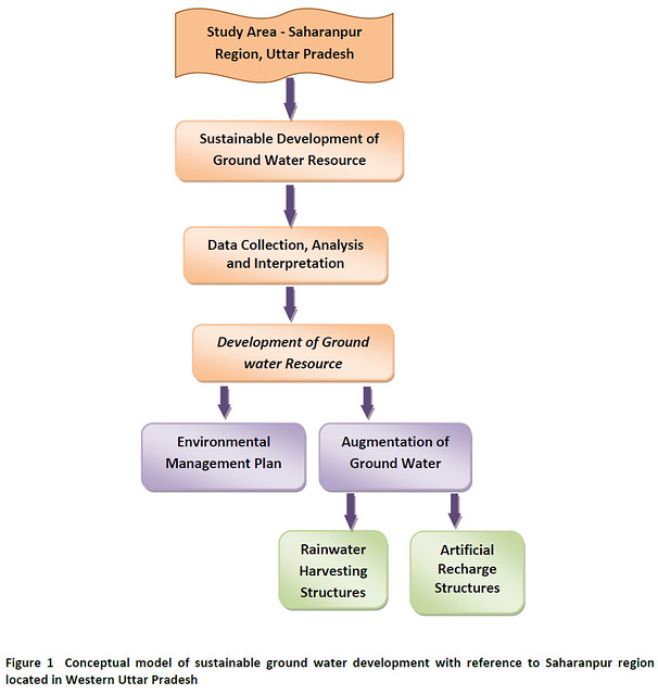
It involves implementation of scheme for a forestation including optimum growth of plants. This effort will enhance the amount and frequency of rainfall, which in turn, would help in the augmentation of ground water system. A flow chart of the artificial recharge plan for the dround water reservoir of Saharanpur study area has been illustrated (Figure 1).
CONCLUSION
The sustainable development is a balanced process which enhances both current and future potential to meet human needs and aspirations. The sustainable development concerns with the optimum realization of different social, environmental and economic objectives of society at one and the same time. Ground water is a renewable natural resource, however, it has limited extent and hence, only a definite quantity of water must be withdrawn annually from a ground water basin. Artificial recharge is a common globally used technique to augment the ground water system.
The need of implementation of artificial recharge plan has been discussed to increase the ground water expediency in Saharanpur area, located in Uttar Pradesh, to cater the present demand for domestic, drinking, agriculture, irrigation, industries, energy and sport sectors.
The paper deals with planning and operation of artificial recharge plan for proper augmentation of ground water system of Saharanpur area by construction of artificial recharge structures such as the gully plugs, nalah bunds, check dams, pits, trenches, percolation tanks, and injection wells. It is suggested that the operation of artificialrecharge plan will provide better results provided if it is added with quality monitoring of recharge water, benefitcost analysis, rain water harvesting, conservation of water resources, development of a forestation and public awareness programmes relating the significance of ground water use.
It is considered that the operation of artificial recharge scheme would greatly help in the increase of ground water system that would make available a buffer stock in Saharanpur region, which will provide timely help in combating natural hazards.
REFERENCES
American Society Civil Engineers (2001). Standard guidelines for artificial recharge of ground water. EWRI/ASCE 34 -01 (ASCE Standard No 34-01).
Central Ground Water Board (2000): Ministry of Water Resources Guide on Artificial Recharge to Ground Water. New Delhi, 59 p.
Centre Science and Environment (2003). Site dedicated to rainwater harvesting, accessed on various dates at http//www.rainwaterharvesting.org
Chandra, Sathish (1979). Estimation and measurement of recharge to ground water for rainfall, irrigation and influent seepage' - International seminar on development and management of ground water resources (November 5-20, 1979)
Charlu, T.G.K. and Dutta, D.K. (1982). Ground water development in India. Rural Electification Corp. New Delhi, 228 p.
Fetter, C. W. (1988). Applied hydrogeology. Merril Publ. Co., A. Bell and Howell Information Co., Columbuc 529p.
Fetter, C. W. (1990). Applied hydrogeology. C.B.S. Publishers. & Distributors, Delhi., 592 p.
Karanth, K.R. (1987, 1994, 2003). Groundwater assessment, development and management. Tata Mc-Graw Hill Publ. Co. Ltd. New Delhi, 720 p
Kumar, C. P. (1977). Estimation of ground water recharge. ISH Jour. Hydraulic Engineering, vol. 3, no. 1, pp. 61-74.
Muckel, D.C. (1948). Replenishment of ground water supplies by artificial means. Tech. Bull. 1195, Agric.Research Services, U.S.Deptt. Agric, 51 p.
Pettyjohn, W. A. (1988). Introduction to artificial ground water recharge. Scientific Publishers, Jodhpur, 62 p.
Raghunath, H. M. (1962). Ground Water. Wiley Eastern Ltd. New Delhi, 456 p.
Saini, R.K. (2003). Groundwater quality studies in Saharanpur. Indian Inst. Technology, Roorkee, Unpbl. M.Tech. thesis, 72 p.
Shrivastava, M. (2000). Hydrogeological investigation in relation to ground water depletion and probable curative measure through artificial recharge with special reference to Jhunjhunu, Pali and Sirohi districts. Univ. Rajasthan, Jaipur, Unpubl. Ph. D. thesis, 123 p.
Singh, V., (2007): Hydrogeoenvironmental appraisal of Saharanpur city region, Uttar Pradesh. Vikram Univ. Ujjain, Unpubl. M. Phil. Thesis, 81 p.
Singh, V., and Dev, P., (2009): Rainfall variation analysis and future trend in Saharanpur district- environmental context. Indian Jour. Environmental Protection, vol. 29 no 8, pp. 710-718.
Todd, D. K. (1959). Groundwater hydrology. John Wiley and Sons, Inc., New York, 336 p.
Todd, D. K. (1980). Groundwater hydrology. John Wiley and Sons, Inc., New York, 535 p.
Vocational Business (2003).Training, developing and motivating people by Richard Barrett
Business and Economics, vol. 63, pp. 313-347
Walton, W.C. (19700). Groundwater Resource Evaluation. Mc Graw-Hill Kogakusha Ltd. Tokyo, Japan, 664 p.
Vartika Singh & Pramendra Dev
DTRL, Defence Research and Development Organization New Delhi
School of Studies in Earth Science, Vikram University, Ujjain, M. P.
Posted by


