


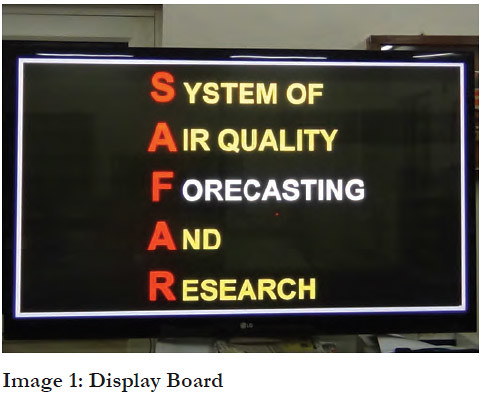
The Ministry of Earth Sciences (MoES), Government of India, has introduced the System of Air Quality Forecasting And Research (SAFAR) to provide location-specific information on air quality in near real time and its forecast 1-3 days in advance in major metropolitan cities such as Delhi and Pune. This system benefits the general population by increasing awareness on climate related events and in forecasting adverse environment effects. The World Meteorological Organization has recognised SAFAR as a prototype activity on the basis of the high quality control and standards maintained in its implementation. Hospitals and medical colleges which have set up SAFAR stations have the data available for their own research and scientific usage and to identify, for instance, the rise of ailments like bronchitis cases in the area.
Rationale
Systems to scientifically assess the quality of air and collate information for the general public had not been adequately developed in India earlier. Private institutes and research organisations had conventional techniques, used in a sporadic manner, for monitoring air quality. On the other hand, for the government, this role was performed by the pollution control boards using analyses equipments. A high resolution atmospheric chemistry model was used in government institutions which, however, extended only up to monitoring andnot forecasting, and required many input parameters to maintain accuracy.
Awareness about air quality – the level of air pollution and emission levels – is generally low. It has a direct impact on the life of the common man, primarily in the form of health and agricultural issues. Before the introduction of SAFAR, there was no way to know the status of air quality in a period of 48-72 hours. Prescient knowledge about air quality has a bearing on how the state can prepare for upcoming disasters, changes in transport availability andflight parameters.
 The project initiated by the Ministry of Earth Sciences and Indian Institute of Tropical Meteorology (IITM), Pune, is the first of its kind in India, which has been developedprimarily for the purpose of forecasting air quality. The project emerged from the need to assess air quality during the Commonwealth Games (CWG), New Delhi, in 2010.
The target beneficiaries were sports persons (especially athletes, who breathe in ten times more air) for whom air quality information is useful in determining the effect it has on their physical capabilities.
Objectives
One of the main objectives of the project is to be able to provide forecasting information on air quality and not simply monitor the quality of air. SAFAR also allows translation of highly scientific air quality information in a simple format for easier understanding. It also increasesawareness on the importance of knowing the air quality in one’s area and using that information to understand its impact. In addition to the above services, it now also provides forecasts on weather, emissions and UV radiation in the region. Currently, SAFAR is active in two metropolitan regions of India – the National Capital Region of Delhi and the Pune Metropolitan Region.
Key Stakeholders
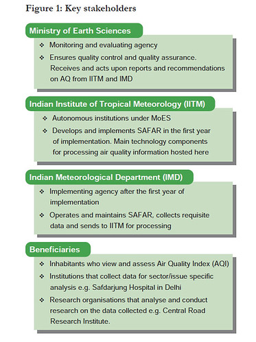
SAFAR is implemented under the MoES but is implemented by IITM, an autonomous institution of the MoES based in Pune, and the Indian Meteorological Department (IMD) in New Delhi.
Implementation Strategy
The concept of an air quality monitoring and forecasting system was decided upon in the run up to the CWG Delhi 2010. Studies were conducted for two years to determine the exact locations for the monitoring stations. Primary data was collected for building the system, after which monitoring stations were placed at different stadia and the pilot test was run for a period of 15 days. Finally, SAFAR was inaugurated on September 23, 2010.
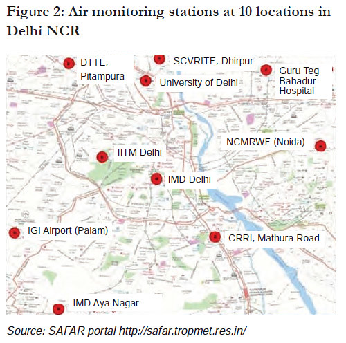
After the CWG, the stations were relocated from areas around the stadium and spread out across the capital. As of 2013, there are 10 air monitoring stations along with weather monitoring stations and 17 display boards at multiple locations in the city.
All the air monitoring stations were set up, operated and maintained by IITM for the first year. Thereafter, IMD took control of operations and maintenance. IITM now plays a supporting role in hosting servers and resolving any technical issues in Delhi, even as it continues toimplement the project in other metropolitan regions.
 a. Process
The SAFAR system integrates several complex components to provide four main products:
1. Air quality forecast, 1-3 days in advance
2. Weather forecast, 1-3 days in advance
3. Location-specific UV index information
4. Emission scenario
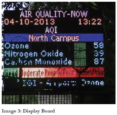
In the case of data on air quality, since SAFAR is meant to cater to the general public, it was decided that technical information must be symbolically represented. Hence, for the first time in the country, an Air Quality Index (AQI) was created to assess air quality on parameterslike prevalence of carbon monoxide, oxygen and particulate matter. The AQI is formulated on a scale of 1-500 units, where each range of 100 units is colour coded in ascending order of pollution. As such, green indicates ‘good’, yellow indicates ‘moderate’, orange indicates ‘poor’, red indicates ‘very poor’ and lastly maroon indicates ‘unhealthy’ quality of air. Similarly, a UV radiation-index was also formulated on a scale of 1-10, where 3 has been marked as the permissible limit, beyond which skin ailments are likely. Both these easy-to-understand indices are now displayed on the electronic screens along with weather forecast information.
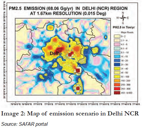
Another important component of SAFAR is the emission inventory. Initially, a large campaign was carried out with the help of local college students in Delhi and Pune to collect information through surveys and existing data.
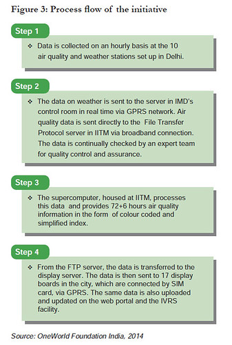 This data was collated by IITM to understand the emission sources and amounts in certain areas of these cities, specifically different sources of air pollution from power generation, transport, cooking etc. On the basis of this exercise, SAFAR is now able to provide high resolution 1km x 1km data on the emission scenario in an area. The inventory is regularly updated based on the information received from traffic departments.
In 2013, IITM developed the Air Quality and Weather Assessment and Data on Hi-Tech-Digital India (AWADHI) which provides fast and detailed information on all thecomponents related to SAFAR on one platform and with a single click. This may be used for accessing a variety of information components on quality control, hardware and communication issues, raw forecast, IVRS data, and others.
At the beneficiary level, therefore, there are four main channels of receiving information:
1. Dynamic web portal – http://safar.tropmet.res.in/
2. LED – Digital Display Board System (DDBS) for screening
3. Integrated Voice Response Service (IVRS) – Toll free No: 1800 180 1717
4. Alert Services – E-mail alerts from safar@tropmet. res.in and SMS alerts for extreme air pollution and weather events.
b. Dissemination
The initiative uses a number of modes of dissemination including digital display boards and a web portal. The portal’s query form finds an audience ranging from school children to the elderly. These queries, around 350 queries per month, are usually responded to within 24 hours. Apart from this, roughly one lakh calls per month are received on the IVRS. Based on the response from the younger and older generations alike, IITM publishes reports in regional languages in Delhi and Pune. Initially, when SAFAR was launched, it received wide media coverage, which is being taken forward through yearly and periodic assessments of the project through press releases.
 A 15-minute documentary was prepared on SAFAR in Delhi describing its inception, implementation and outcomes, which included comments by athletes as well. Visits from schools are also encouraged to educate children about the facilities used and servicesprovided. Scientific workshops or conferences are conducted annually to discuss SAFAR, its research and how similar technology is devised and used in other countries. A workshop along these lines held in May 2010 saw the participation of 300 scientists and 50 foreign delegates.
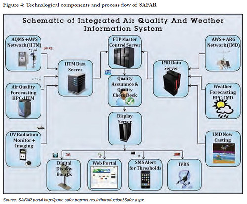 c. Capacity Building
At implementation sites, there is a team of experts to supervise the work of the ground staff. This team is distributed across different parts of the city so as to be able to provide any form of advice/assistance.
The emission inventory development was preceded by a full-day orientation workshop given to a batch of 200 students to educate them on data collection and precautions to be taken while collecting data.
At sites where SAFAR can be used for an organisation’s research interests such as hospitals, the staff undergoes an orientation workshop on instruments, limitations of thedata collected, and the measurements and precautions to be taken.
Resources Utilised
At IITM, there is a team of 15 people comprising senior scientists, technical assistants and research scholars, headed by a Programme Director. At IMD, the team is led by the Deputy Director General of Meteorology and includes experts who supervise the ground staff as well.
The MoES is funding the institutions involved in the implementation of SAFAR at a total cost of Rs. 15 crore per city for Delhi and Pune. This is a one-time allocation. A major portion of the funds is spent on the purchase of instruments, display systems, setting up of the supercomputer, monitoring stations, creating the emission inventory and recurring expenses for communication and maintenance. The server rooms cost approximately Rs. 1 crore.
Impact
Availability of information relevant to improving public health: Awareness on air quality and weather is generated through three main channels that bring information on air quality and weather forecasts to the public regularly – web portal, digital display screens and IVRS. With this kind of information, one can identify health risks associated with poor air quality and high pollution. Importantly, one can take measures to avoid such areas and form mitigation strategies for improving air quality and minimising risk. One of the biggest achievements of SAFAR has been the identification of wind-blown dust (suspended dust) as the major source of particle pollution in Delhi. Wind-blown dust from roads forms 50% of the pollution spectrum, exceeding pollution caused by the transport, biofuel and industrialsectors. This phenomenon is higher in places where there are unpaved roads and where dust gets easily unsettled. Based on this data, a recommendation was given to the authorities highlighting this as a causative factor and also mentioning that the probability could be higher in heavy traffic congestion areas where motorcycles and other vehicles tend to traverse through unpaved roads.
Timely intimation of impending disasters/weather extremities: Disaster management authorities and emergency response centres take advantage of the network and forecast weather and atmospheric risks. If such a risk assessment is made, alerts are sent out to registered users within an hour. For instance, if there is heavy rainfall (more than 30-40 mm) and it is likely to continue raining for several hours ahead, then preventive measures are advised to be taken against flooding. The technical report by the MoES also makes use of emission inventory details produced by SAFAR.
Input for studies on environment issues and health risks: It is not just the people, but also the Central government that has benefited. Domain experts can analyse the data collected so far and study the relation between cause and effect in air pollution and related events. Long term mitigation strategies and new technologies can be devised on the basis of such research. Hospitals and medical colleges which have set up SAFAR stations have the data available for their own research and scientific usage and may use it to identify, for instance, the rise of bronchitis cases in the area. Central Road Research Institute, New Delhi has also set up SAFAR on Mathura Road and uses it to complement its own research and data on air quality, monitoring and related environment measures.
Improvement of crop yields: The information has also been used for improving crop yields after studying the effects of ozone, sulphur dioxide and particulate matter on vegetation.
Health advisories have been released on the basis of SAFAR information: Delhi faced the worst winter pollution in the year 2012-13 in comparison to the previous three years wherein the particulate matter remained consistently at the ‘Very Poor’ and ‘Very Unhealthy’ levels for a month. On research it was discovered that it was due to a change in the wind pattern as well as crop burning activity in the surrounding states. Such long exposure to unhealthy air would have had a considerable impact on the human immune system. Details of weather events that cause a rise in particulate pollution are intimated to the relevant government departments for action. For instance, in 2014, multiple advisories were disseminated to the public regarding bursting of fireworks with the knowledge of the effect that particulate matter has on air pollution in the city.
 Measures for a better environment: Eco-friendly measures such as the switch to CNG, Bharat I and Bharat II compliance measures, moving industries to the outskirts are also based on the worsening of the air quality and scientific information passed on by IMD, which sources such information from SAFAR and other agencies.
The World Meteorological Organization has recognised SAFAR as a prototype activity on the basis of the high quality control and standards maintained in the implementation of SAFAR. It further states that the experience gained will serve as an example within India, in the region of South Asia and globally.
Key Challenges
The scientific and technical staff must be available throughout the initial phase of implementation. Each metropolitan region has unique air pollution and emission inventory parameters and, therefore, is resource intensive at the time of setting up. The walkway shelters (that house the ozone, UV radiation and other air quality instruments) require round the clock security to ensure that they are not tampered with. The data on the basis of which locations are selected has to be carefully parsed to ensure that there is no bias that may come from a nearby polluting source, high rise buildings or trees. Also, the display boards have to be strategically placed in prime locations where lots of people pass.
In the initial days it was difficult to convince partner organisations about the purpose and benefits of SAFAR. There were few organisations such as the Safdarjung Hospital which were willing to set up SAFAR stations with the knowledge that it would contribute to theirown research interests on the health of the people in the vicinity.
Replicability and Sustainability SAFAR, under the umbrella of the MoES and with itsenvironment-friendly mandate, does well on financial and environmental sustainability. In terms of social sustainability, the initiative requires active participation by the general population. Consistent awareness generation efforts will be necessary for ensuring that SAFAR is relevant to the needs of the public.
SAFAR has high potential for replication in metropolitan regions. It has been successfully replicated in the Pune Metropolitan Region (May 2013). It has now been implemented in Mumbai (2013-14) and three other metropolitan regions. However, SAFAR’s replicability in rural areas is yet to be explored. Further, the central government has envisaged a project on metro advisories for air quality and weather for city sports tourism. This is expected to be implemented in five different cities in India, in addition to New Delhi and will make use of theservices provided by SAFAR.
Conclusion
SAFAR, the air quality and weather monitoring system, is a first-of-its-kind initiative in the country, which has already shown positive impact in the areas of public health and generating important data for the government. With such information, authorities can identify the health risks associated with poor air quality and high pollution. Importantly, it allows the government to take measures to avoid these areas and form mitigation strategies for improving air quality and minimising risk.
SAFAR has proven to be successful simply because it has allowed the government to get an insight into environmental issues needing solutions. In short, the SAFAR system is an innovation that has proven its efficacy in public health as well as in disaster management and mitigation strategies.

Posted by


