


The Himalayan Mountain system is dotted with 12 rivers, out of 18 major rivers of the country. Hundreds of small rivulets and thousands of streams make the Himalayas as “Water Bank of Asia”. This constitutes 42% pf the total of the country. It is ironical that these rivers have not been of any use to the local resident, except for the minor utilities in the form of watermill, occasional irrigation, not exceeding 2% of the total potential use (Joshi 2004)
The government scheme of water supply has largely failed due to its appropriate nature, poor maintenance and distribution. This has plunged mountain residents to severe water shortage, so much so that women and girl have to walk kilometers for potable water. In Uttranchal, out of total 16000 villages 8800 villages have been placed as water scarce villages. The districts like Almora, Pauri, Tehri, Pithora Garh and Chamoli are facing drinking water crisis (Joshi 2004).
72% women and 14% children have to bear the responsibility of carrying potable water. The average 60% women have to walk ½ km while 10% of them walk 4 km for fetching water. The villagers are not satisfied with the government scheme.
In district Tehri, Smt Bachni Kaunthura has to climb 1.5 km, 5 times to collect water with a back load of 40 litres of jerry cane. Smt Shankara Devi of Village Nagri of district Tehri has to engage herself for water collection from 3 a.m in the morning. There is often quarrel among women on the issue of water. When the quantity being the priority is not met out, quality of water becomes the secondary need.
They believe that traditional methods of water harvesting were the best. By their own efforts, where government has failed, villagers are making at hilltops to charge spring, an ageold practice like in Maikoti (Rudraprayag).
Women are suffering lot in every village where water problem is severe. Natural sources are drying up which adds the kilometers for women everyday to quench the thrust of their family as well as animals.
Women are the major workforces in whole Garhwal region. They work from early morning to late evening to serve the family. They do all household work from cooking to cleaning and washing clothes and soiled utensils as well as look after their children and animals. Women also collect the water required for cooking, cleaning, washing, bathing and drinking both for human beings and animals.
Smt. Kundana Devi of the village Kandakholi, in district Tehri, which is situated above 1800m M.S.L, told with tears in her eyes that there is pipeline from Govt, but water comes weekly or sometimes fortnightly only for one hour. There is no natural source nearby. The govt. water supply is through a pumping system, lifted from Bhilangana river a tributary to Bhagirathi which is at about 700m M.S.L Now they reduced the number of animals only because of water crisis. The only source close to the village is about 1.5 km. The discharge rate is only 1.0 liter per minute. A woman has to wait for minimum of 1 hour to fill a buntha (20 lt.) of water. They get up early in the morning to queue for water and go to bed late around 11.30 after storing enough water for next day work.
Smt. Shashi Devi of Kandakholi says that we take bath one by one and only once in a week because of the water problem. Or they go very early or very late to the spring to take a bath or wash the cloths. They also told us that water is also reducing every year. They are also afraid of drying of the only existence source.
Similar stories were told by the women in other villages also. 269 ladies of 32 villages in two districts of Garhwal Mandal in Uttaranchal were interviewed for water. It was observed that a glass of water is much more precious than Kerosene oil in the villages where people have to travel more than 8 km for one brass pot (Gagar) of water or have to pay to more than Rs. 50 for one 15 liter of tin. Most women walk on an average of 5-10 km per day just to fetch the water. In some villages condition is worse, where women walk between 20-24 kms per day spending 5-9 hrs per day just for water.
Villagers also blamed Govt. for their hand pump scheme everywhere. According to them natural water sources are drying wherever there are hand pumps.
During the survey in Jaunsar area of district Tehri Garhwal, village Nagthat, Duena, Vishoi, Gadol, Jandoh, Chitar, Chichrad and Gangoa were visited. It was observed that water in the region is mostly acidic in nature. Water problem in Chitar and Gangoa villages is very severe, where people carry water on mules from 8 – 10 Km far from the village. Because of the poor water quality, most of the villagers in the regions are suffering from many diseases related to skin and teeth. Natural resources of water in the area are very few and they are also disappearing very fast. During the survey, Smt. Nisha Devi of village explained that they are not getting enough water for their animals so they take their animals to the spring about 2-3 kms away.
In the villages where govt. pipeline is available, water quality is quite good but due to the carelessness of extension workers, they don’t get water. Especially during the two months in the summer they face lot of problem. Another problem is of maintenance of the pipeline, whenever it is damaged by one or other reason, repairing is always delayed. Women are not able to do their normal work due to the time spent to fetch the water. Most of the women in water scarce villages suffer from the joint and back pain. Girl child education also got affected in such villages because after mother they have to bring the water. Boys also spent their time for water collection as well as to take the animals to the water sources, which affects their studies. Water mills in most of the villages are either closed or are seasonal, because of reduction in the water in the streams.
Suggestions of women for improvement:
1. Proper water conservation measures should be used. People should be made aware and trained on the techniques of water conservation.
2. For the conservation of water in the fields, khals, chals (small ponds) should be made.
3. Natural water sources should be restored.
4. Watermills should be improved so that it can run in less water also.
5. Government schemes should be implemented properly
Tehri Dam Project
The Geological Survey of India conceived the Tehri project in 1949. The Tehri site was considered suitable, provided that sub-surface investigations did not reveal any adverse factors. However, it was only in 1963 that the detailed investigation was made. The site was finally confirmed, after the visit of the then Union Minister for Irrigation and Power, K. L. Rao in 1965. By 1967, several Indian and foreign experts visited the dam site and recorded their opinions (Paranjpye, 1988).
Apprehension was expressed with regard to the geological vulnerability of the area at and around the site – the unstable hill slopes that would constitute the reservoir run areas and the seismic danger at the site. The preliminary investigations by the Geological Survey of India had revealed a riverbed fault at the dam site and this strengthened the decision to opt for a concrete dam.
Tehri Dam is a gigantic multipurpose project being built on the Ganga at Tehri in the Garhwal Himalaya. The cost of 260.5 metre high dam project which was originally estimated at about Rs.197.29 crores in 1972 has now escalated to Rs.10,000 cores. The dam has been surrounded by controversy since its very inception. The main reasons why the citizens of Tehri Garhwal, several scientists and ecologists have opposed the Tehri dam are the following (MatuPeople’s Organisation, 2002):
i) The uprooting of more than one lakh people, directly and indirectly from their homes in Tehri town and surrounding villages.
ii) The high risk of dam failure, whether by an earthquake of higher intensity than what the dam design provides for, or by other factors; in the case of such event the acute threat to dense urban and rural habitations in the downstream area, including the culturally important towns of Dev Prayag, Rishikesh and Haridwar.
iii) The threat of RIS or reservoir induced seismicity, after the creation of the huge new artificial reservoir, to the people living around this reservoir, a threat that arises from the height of the dam and other factors favourable to RIS found at and around the dam site.
iv) The threat of rapid siltation of reservoirs due to the high erosion in the catchment areas. Some experts assess the present life of the reservoir at only 60 years.
v) The project has been steeped in financial waste and corruption. The Comptroller and Auditor General has raised disturbing questions about this project.
vi) Adverse impact on fisheries, other fauna and flora, and various other adverse effects.
The 260.5m high dam is more than two-thirds the height of the Empire State Building, and is on the river Bhagirathi, a tributary of the mighty Ganga, India’s holiest river. The most worrying feature of this reservoir is that it is being constructed in the Himalayas, one of the most geologically unstable and earthquake prone regions on the earth, as the subcontinent of India continues to slip and grind its way northwards into central Asia. Indeed, it is well known in engineering circles that the massive artificial water bodies created by dams have a tendency to increase the frequency, and perhaps the intensity of earth quakes (Davies and Day, 1998).
The Tehri dam will impound 3.22 million cubic metre of water. The reservoir will extend up to 45 kms in the Bhagirathi valley and 25 kms in the Bhilangana valley with a water spread area of 42.5 sq. kms. The reservoir is expected to irrigate 270,000 hectares of land. The turbines in the powerhouse at Tehri have an installed capacity of 1,000 MW, so that they can operate essentially to satisfy the peaking power requirements of Uttar Pradesh Power Grid. (Shiva and Jalees 2003)
Besides, the Tehri dam is also expected to supply 500 cusec of drinking water to Delhi. While cost has increased from 200 crores in 1972 to about Rs.10,000 crores, the benefit component will not change in real terms because the height of the dam, and therefore the water available for irrigation will remain constant. Similarly, as there will be no change in the waterhead, there can be no change/increase in power generation. This will make the cost benefit ratio even worse.
An important aspect of the Tehri Dam is its proximity to the Chinese border. We cannot ignore the fact that we had war with China and in future if there is war, Tehri dam might be an attractive target for Chinese bombers. It is a well-known fact that during the Second World War, the Allied forces and Nazi Germany busted each other’s dams without any qualms. Since then, it has been wisely decided by most countries not to build dams too close to unfriendly borders. A dam at Tehri, barely 100 kms from the border, is strategically vulnerable. (Shiva and Jalees 2003)
However, the main controversy surrounds the all-important feature of seismicity at the Tehri location. It is feared that if an earthquake of intensity equal to eight or more on the Richter scale were to occur, the dam would collapse, and the catastrophe would lead to consequences that would greatly outweigh the benefits from development.
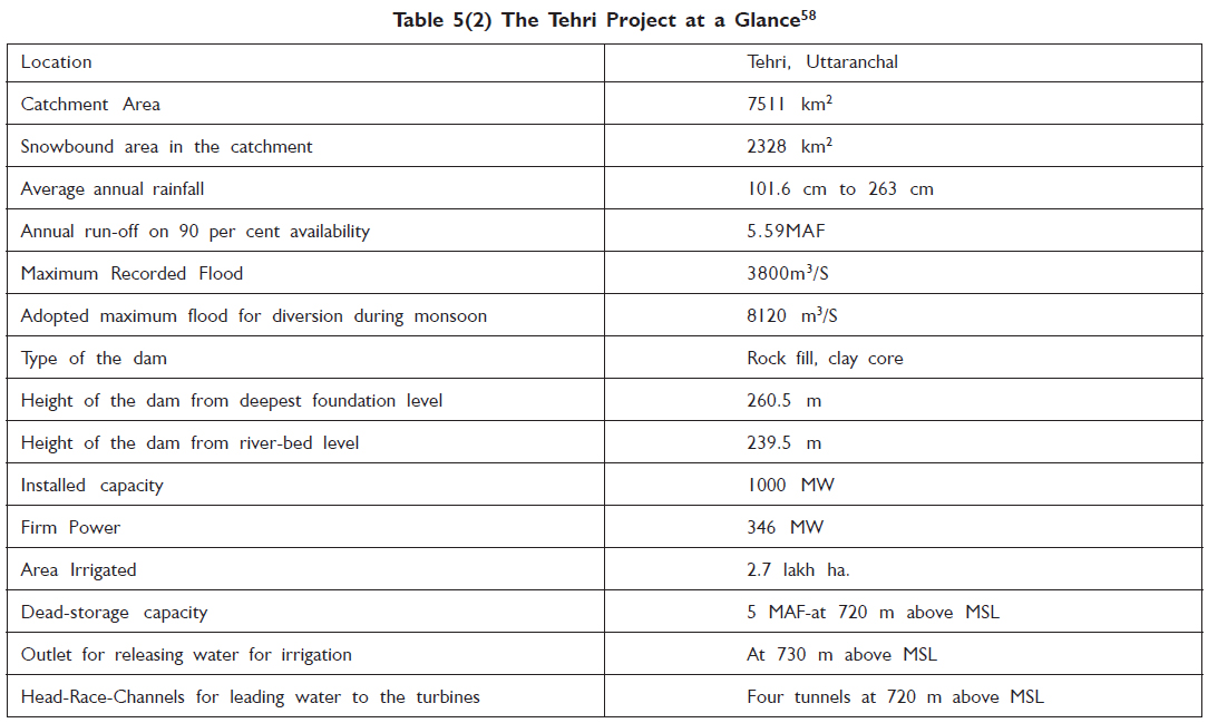
Galileo (17th century) stated: “I had less difficulty in the discovery of motion of heavenly bodies in spite of their astonishing distances than in the investigation of movement of flowing water before our eyes.” The significance of Galileo’s statement acquires even greater relevance today when one is dealing with a river like the Bhagirathi, which originates at an attitude of 12,000 ft. from a glacier, which is 26 km long and is fed by some of the highest mountains in the world. The Bhagirathi has a catchment area of 7,511 sq. kms out of which almost one third, i.e., 2,328 sq. kms, is snow bound as it lies above an attitude of 16,000 feet above mean sea level. ( Shiva and Jalees 2003)
In 1969, the project authorities had estimated the rate of sedimentation as 1.7 acre-feet per sq. mile of catchment area per year. At this rate, the life of the dam was estimated as 100 years. However, as empirical data started coming, the annual rate of sedimentation went up substantially, i.e., 2.8 acre-feet per sq. mile by 1980 or 13.5 hectares per 100 sq. kms per year. Subsequently, at this rate of siltation, the expected life of the dam reduced to 61.4 years.
In case the Tehri dam collapses, the impact would be as given in table 5 (1). As seen in the table, in less than an hour and a half the water would hit Rishikesh and Haridwar and wipe out these two cities. This is certain because the height of the water would be 260 metres and 232 metres respectively. This would result in horrific loss of life and property. In order to assess how this can be minimized and to what extent, a disaster management plan is essential. This plan would also prescribe the communications and personnel networks that would need to be in position and the costs involved in all this. These costs would have to be calculated as a part of the cost benefit analysis of the project (Singh and Banerjee, ed. 2002).
Source: Shekhar Singh and Pranab Banerjee (ed., 2002): Large Dams in India: Environmental, Social and Economic Impacts, Indian Institute of Public Administration, New Delhi.
It needs to be noted that Tehri Dam Project is only one of the over 40 hydel multipurpose projects, which have been constructed, or being constructed/ investigated in the Garhwal region. These projects include big, medium and small projects (Paranjpye, 1988).
The cost benefit ratio
B/C ratio = Annual Benefits/Annual Costs = 21007.47/37539.31 = 0.56
The annual benefit per cost rate is calculated as 56 per cent. In other words, for every rupee put on Tehri project, only 56 paise will be recovered (Paranjpye, 1988).
The project has also not made any provisions for rural electrification schemes in the surrounding areas, even though the dam will submerge about 100 villages in two districts of Tehri Garhwal and Uttarkashi. On the other hand, the project will supply enough to large industries and urban areas in the plains of Uttar Pradesh.
The locals are totally alienated from the project. Hence the authorities have foregone the advantage of having first hand knowledge from the people, say the types of trees most beneficial for water retention, their fuel requirements, etc.
 Source: Paranjpye, Vijay (1988): Evaluating the Tehri Dam: An Extended cost Benefit Appraisal, Studies in Ecology and Sustainable Development, Series No. 1, INTACH, New Delhi.
Another controversial aspect is the catchment area management by the Forest Department, which had been entrusted with the planting of trees to build the soil. Though the catchment area is around 7 lakh hectares, the forest department is entrusted with only 52,000 and odd hectares for greening.
There are 12 rare and endangered species of flora and fauna, which may be disturbed by inundation. They are: (Kumar 2001)
1. Cirrhopetalum hookeri
2. Eulephia hormusjie
3. Gastrodia orobunchoides
4. Herbenasia triflora
5. Listera microgolties
6. Saccolabium olistichum
7. Allium rubellun
8. Gagea preudoreticulsta
9. Tulipa clusians
10. Abgcuia tongleusis
11. Poa rhadiana
12. Preudoduntonia himalaica
The construction of the reservoir would push the fauna to the higher slopes in the area. The flora that was thriving on the facile conditions in the valley would face with a tougher life. The fauna already inhabiting the higher slopes would share scarcer resources and smaller habituating area of the land, which they are not accustomed to. In their fight to survive against new odds, we may find ourselves the losers with many species becoming rare.
Rehabilitation: Human Factor
Involuntary displacement of human population is always traumatic. Irrespective of the causes leading to migration the degree of suffering experienced by such people simply cannot be quantified in money values and even in words; it can be described only inadequately. In the case of natural calamities and wars one notices a sense of helplessness because the causes and consequences are so diverse and widespread that compensation and restoration become either intractable or apologetic. However, this need not be the case when the displacement is the consequences of pre-planned developmental projects undertaken by the government or other public authorities. But, unfortunately ousting of people likely to be submerged under irrigation or hydel power dam is a classic case where hardships are imposed on people, in spite of the ‘pro-people’ laws and policies proclaimed by the government.
The history of this phenomenon in India dates back to 1884 when the British Government passed the Land Acquisition Act, and legitimised the displacement of people whose lands were to be acquired for “public purposes.” The Act was based on the general philosophy that the interest and well being of a few could be subsumed by the larger interest of the society, which, in practical terms amounts to the interest of the state.
The Act however was very clear on the point that such displacement does not indeed cause great sacrifice and therefore, such people should be fully compensated for all the losses, and that if such land acquisition is not voluntary, an extra 15 per cent of the total compensation be paid in addition.
Over the years, experience, however have shown that almost all the displaced persons become the refugees in their own country, and end up penniless, landless and homeless.
The Tehri Dam Project has affected around 125 villages including the old Tehri Township. Thirty-nine villages are going to be fully affected and another 86 villages (number may possibly increase) would be partially affected. Wherever less than 75 per cent of the families are in the displaced category and have to be rehabilitated, all those villages have been categorized as partially affected. That means that even where 74 families out of a total population of 100 families are eligible for rehabilitation, they have been classified as belonging to partially affected villages.
According to a new estimate made by the Rehabilitation Directorate, around 5,291 urban and 9,238 rural families would be affected due to construction of Tehri dam. 3,810 rural families have been partially affected by the dam. In reality, however, the number of affected families is much higher. As of now, the number of urban families displaced by the dam has reached 5,500 and the number of rural displaced families is more than 12,000 (Matu-People’s Organisation, 2002).
The State Government has deliberately submitted lower figures of the displaced families in the affidavits filed in the Supreme Court of India in 2002 ignoring the ground situation. The Government has not still compiled the aggregate statistics of the affected people. However, if it is assumed that each urban family has roughly five members and each rural family consists of seven members, the total number of affected persons, may in fact, be more than 1 lakh. Even 1,605 families of government employees have been categorized as displaced families (MatuPeople’s Organisation, 2002).
The report published by Peoples Union for Civil Liberties highlighted rampant corruption and other irregularities prevailing in the Tehri Dam Project. For instance:
● Out of a total outlay of Rs.582 crores for rehabilitation measures, only Rs.94 crores have been earmarked for the displaced people.
● Out of the budget for rehabilitation, residential premises for District Magistrate and the Superintendent of Police were earmarked at a cost of Rs.47 lakhs and Rs.43 lakhs respectively. A sum of Rs.2 crores was earmarked for a field hostel, though no amount was spared for building Dharamshalas.
● Sale of residential flats by the rehabilitation authorities like builders.
● Rehabilitation becomes the business of moneybags.
● Lack of clear rehabilitation policy and disregard for Government Orders.
● Significant recommendations of Dr. Hanumantha Rao Committee were not accepted.
● Flawed evaluation of socio-economic structure of the community.
● Exodus of people rather than meaningful rehabilitation is happening in Tehri.
In the rural areas, there are only two categories of displaced families, namely, landowners and landless agricultural labourers; and no estimate is done (table 5.3). Whereas, in the urban areas there are many other categories made for rehabilitation. Even government employees and organisations have been categorized as displaced families.
 (Matu people’s organisation 2002)
Partial Submergence: Unrealistic Demarcation,
Eighty-six villages would be partially submerged by the Tehri Dam Project. This includes those villages where 70-75 per cent of families and land are going to be affected. However, eligibility for the status of a fully affected village has been determined as affecting 75 per cent or more families and land. Even those villages, where 25-30 families would remain after submergence, have been affected. Although denomination of villages as partially affected has been done on a mathematical formula (wherever the land of 75 per cent of the families is involved), no estimates have been prepared to take into account the existence of link roads, gazing places, local markets, civic amenities, ‘ghats’ along the banks of the river drains, and the disintegration of social life. If the people were deprived of all the amenities in villages where only 25 to 30 per cent of the people would be left (in some villages the number is as less as 5-10 families), how are these people be expected to retain their existence and identity as part of the village society?
Cut off Area
Around 80,000 people are going to be indirectly affected by the construction of the dam. The area is in Pratapnagar tehsil. This area has been dependent on Tehri Township for various civic amenities. Due to the construction of the dam and the resultant reservoir, six bridges (two motorable and four pedestrian) on the Bhagirathi and Bhilangana river would be submerged, thereby completely disrupting the roads connecting the district, block, state and national capital and other areas. As a result, the distance to be traversed between these places would increase by 100 to 150 kms. A large part of the cut off area falls in the rim area of the dam and partially submerged area.
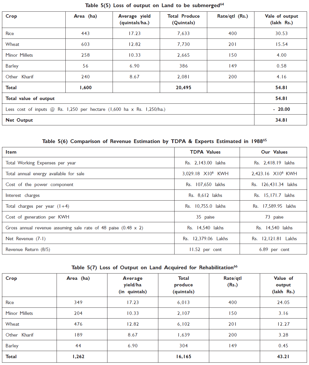
Benefits and costs, loss of output on submerged land, loss of output on the land for rehabilitation and comparison of revenue are given in tables respectively.

 Source: Paranjpye, Vijay (1988): Evaluating the Tehri Dam: An Extended cost Benefit Appraisal, INTACH
The Secret Reports of Geological Survey of India
The idea to construct a big Dam in the unstable and geologically sensitive mid-Himalayan region has been mired by innumerable controversies. The government, on the other hand, claims that the dam design has been prepared keeping in view the geological aspects. Yet many questions arise. What would be the impact of the reservoir on the mountain habitations?
The Geological Survey of India has identified as unstable large tracts above the rim area, which may face land slides in future due to the reservoir. Many villages are located in this area. Though the report has been classified as secret, many significant issues highlighted by the report have become public.
When subsurface explorations were carried out on advice of the Geological Survey of India in the 1960s, a major fault was found at the dam site that has been fully or partially proved. In the GSI report it has been stated: “in the area encompassing the rock fill dam, the rocks exposed are the massive phyllitic quartzites, the schistose and sheeted phyllites of grade III and IV quality and numerous, cross as well as foliation sheet-zones of grade V quality. These alternative bands of phyllites and quartzites are of the Chandpur series, and at some places up to 20 bands can be counted.” And finally, it said, “the riverbed sheet-zone has been proved by drill holes and the true thickness of this zone below the core of the rock fill dam has been established to be 11.6 metres.”
About the seismicity, the Geological Survey of India reports that the proposed project site falls between isoseimals VIII and IX of Kangra Earthquake (1905). In the vicinity of the Tehri dam, the following tectonic features exist:
1. The Srinagar Thrust is located about 4 kms from the dam-site, which brings the rocks of the Bharat Series against the Shimla and the Chandpur phyllites.
2. The Gadolia Tear Fault was traced from village Paukhal to village Nelda.
3. The Tehri Tear Fault has been traced near Nandgaon.
4. The Tehri Tear Fault has proved the existence of a fault running along the river course, and it represents the just older branch of the Tehri Tear Fault.
5. The Deul Tear Fault passes through terrace gravel and there is a scarp about 15 m high along its inferred trace.
The GSI Report further states: “The seismicity of the thrust and faults is not known as no seismographic data exists in this connection.” And in the Tehri dam detailed project (1983), it is stated that epicentres of 77 earthquakes lay within a radial distance of 320 kms from the proposed dam site. The nearest epicentre was located 35-40 kms northeast from the site. Most of these quakes had a magnitude of 5-7 on the Richter scale. (Shiva and Jalees 2003)
Tehri (Historical Trihari)
The biggest township, which is going to be submerged in India, is perhaps Tehri. Instead of augmenting its own prosperity after independence, the Tehri township is being devastated in the name of oft-repeated national development. This is an ancient land, which is being submerged and devastated on the pretext of developmental projects.
The place where Tehri Dam is being constructed, finds a mention as ‘Dhanushtirth’ in the ‘Skandha Puran.’ The confluence of Bhagirathi and Bhilangana rivers is just 500 m from the main gate of the dam. This confluence is known as ‘Ganesh Prayag,’ also known as Trihari – the confluence of three rivers and later called Tehri. Swami Ramtirth, the founder of ‘Practical Vedanta,’ adopted Trihari as an abode of meditation and ‘nirvana.’
The king of Garhwal, Sudarshan Shah belonging to Panwar dynasty, built Tehri township as the new capital of the state in 1815 AD. Prior to this, the capital was Srinagar Garhwal, which had been captured by the East India Company. The capital Tehri built by King Sudarshan Shah witnessed royal grandeur for almost 133 years.
The Garhwal state however witnessed decline after the reign of the sixth king. Till the state’s decline, Tehri continued to be the capital. Being the capital, Tehri became the hub of education, literature, culture and politics. Even after independence, Tehri retained its importance. It was the centre of peoples’ movements. Chipko, Prohibition and Uttarakhand movements reverberated in the streets and markets of Tehri and chronicle the grandeur of the township.
Shri Dev Sumar had undertaken a marathon 84-day old hunger strike, which is only second in duration in the world history. The fast had been undertaken to gain freedom from the royal rule. After 84 days, Shri Dev Suman passed away and became a martyr.
After visiting Yamunotri and Gangotri, most of the pilgrims heading for Kedarnath and Badrinath have to pass through Tehri. Even when there was no motorable road, Tehri was the traditional route of the pilgrims.
Unlike in other places, where construction of dams has taken place, the displaced belong to highly educated middle class families. According to the 1992 statistics of the National Literacy Mission, the literacy rate in Tehri had reached 98 per cent.
Besides education and literacy, the economic condition in the township was admirable. Only 5.54 per cent of the houses were thatched. Although Narendranagar was the district headquarters, more than 40 government offices were located there including the District Court. All civic amenities were available for the residents at a distance of 2-3 kms. Since Tehri was the central point and the nearest market for the adjoining 200 villages, there was lots of hustle bustle and the place used to be quite crowded.
The Historical and Cultural Heritage of Tehri Region
In Tehri, there are religious, cultural and archaeological places and monuments of importance, which require conservation efforts. However, there is no plan for conserving the heritage in the submergence area of the reservoir.
In fact, some Dharamshalas (places of residence for the pilgrims), rock scriptures, and unique craftsmanship on wood and stone still exist in the precincts of Badrinath Temple complex. Nearby, the staircases of ghats reaching the innermost depths of the confluence of Bhagirathi and Bhilangana rivers still exist.
The Badrinath complex consists of a large number of intricate high-domed mosque like temple structures having unique, expansive metal sculptures of presiding deities like ‘Satteshwar Shivling,’ ‘Bhairav Panchmukhi Hanuman,’ ‘Raj Rajeshwari,’ ‘Laxmi Narayan,’ ‘Ranganath,’ ‘Ganga Dakshin Kali,’ ‘Shitala Mata’ – all these still exist.
The ‘Ashtavakra Rishi Shilas,’ ‘Gopeshwari Ling’ and ‘Raktavarna Ganesh Shila’ on the confluence of Bhagirathi and Bhilangana rivers including the ‘Shish Mahal’ in Simalsu have already been submerged under the spate of water and sand.
In one of the Hindu Hymns, “Kedarkhand,’ Tehri and the important adjoining places find mention, and these places are tragically in the submergence area of the Dam.
Legend has it that Aadi Sankaracharya had been responsible for building the ancient temple in Malidewal village of Bhagirathi valley.(Shiva and Jalees 2003)
July 29, 2004 was a black day for those residents of old Tehri town who had decided to remain back. At around 2 p.m, the water in the lake surrounding the empty town rose and entered their homes. The 20 or so families had to run for their lives, grabbing whatever they could. The residents blame the Tehri Hydro-Development Corporation (THDC) which they say had closed the Tý tunnel in March 2004. This together with the monsoon rains raised the level of water in the reservoir up to 655 metres on the fateful day. The closing of the tunnel violated the supreme court’s order of 2003. The apex court had ordered that no tunnel be closed, or reservoir filled any partner, till rehabilitation was completed (Yadav 2004.)
Disaster struck at the Tehri dam site at 10.15 on August 2, 2004. A huge landslide inside the vertical shaft of a tunnel claimed the lives of 29 workers and left about 12 injured. The victims were working at various levels of 240 metre shaft and in the two horizontal tunnels that it connects. The horizontal tunnel at the top is called the Intermediate level out let (ILO). The ILO and the vertical shaft are meant to drain excess water from the dam reservoir once it is filled to the tunnel, Tç at the bottom of shaft. Draining excess water is important because this dam is on earth and rockfill dam, which can be damaged if water passes over it. But such a dam can withstand seismic vibration to an extent. Since Tehri is an earth quake prone region, so the authorities had settled on an earth and rockfill dam and not on concrete dam.
At the time of the incident, concretes work was going on T3 to strengthen the tunnel. In the ILO, workers were involved in digging and excavating activities.
According to J.P Gaur of Jai Prakash Industries, the contractor is responsible for constructing the dam structure. The dam is strong, but inherently the mountains are weak. The comment begs the question: was such a tragedy foreseen? And if so, what steps had been taken to protect the lives of the workers from the ‘inherent risk’? (Yadav 2004).
The dam authorities and successive governments have repeatedly said that the life span of the dam would be 100 years. But many disagree. Siltation will take place much faster than expected life. Says, “ K.S. Valdiya, former director of the Walia Institute of Himalayan Geology.” Sums up, “ The ghost may not be there but the fear of the ghost makes your life miserable, referring to the earthquake and the possibility’ of dam collapse. (Yadav 2004).
Meanwhile, the anti-dam movement spreaded by Shri lal Bahuguna fizzled out. Rehabilitation issues were somehow lost in all the noise against the project itself. And the protracted construction period meant that the rehabilitation could never be carried out satisfactory.
Lots of stories relating to messy rehabilitation float around Tehri and the surrounding villages. There are examples of people who have taken compensation multiple times, people who were not entitled and still got hefty compensation coupled with houses and shops in New Tehri. Endless tales of corruption do the rounds. But at the other end are those genuine claimants, who did not get anything and still are running from pillar to post. The situation is worse in the villages. For them it is not just relocation but an entirely new socio-cultural environment. (Yadav 2004).
New Tehri: In order to settle the residents of Tehri, the New Tehri Township is being developed. It is being built above Bauradi village, at 1950 metre above sea level. As compared to Tehri, there is marked difference in the geo-morphological make up, climate and weather conditions.

Hydel and multipurpose projects in Ganga Yamuna Valleys, Garhwal
Following are the hydel and multipurpose projects being built and/or proposed in Garhwal region (Bharat Dogra, “Dams, Barrages and Future of Garhwal,” in Friends of Chipko, undated, Ignoring Reason, Inviting Disaster: Threat to Ganga-Himalaya, New Delhi).
A. Bhagirathi river projects
1. Bhairon Ghati Hydel Scheme I
2. Bhairon Ghati Scheme II
3. Loharinag Hydel Scheme
4. Pala Maneri Scheme
5. Maneri Bhali Hydel Scheme I
6. Maneri Bhali Hydel Scheme II
7. Tehri Dam Project
8. Koteshwar Dam Project
B. Alaknanda River projects
9. Rishi Ganga Scheme
10. Lata Tapovan Scheme
11. Markur Lata Scheme
12. Tapovan Vishnu Gad Scheme
13. Vishnuprayag Scheme
14. Vishnu Gad Pipalkoti Scheme
15. Bovla Nandprayag Scheme
16. Karnaprayag Dam Project
17. Utyasu Dam Project
18. Srinagar Dam Project
19. Bhagoli Dam Project
20. Padli Dam Project
C. Ganga River Projects
21. Kotlibhel Dam Project
22. Rishikesh Chilla Scheme
D. Projects on Yamuna, Tons and Tributaries
23. Hanuman Chatti – Saina Chatti hydel scheme
24. Saina Chatti – Gangnani Scheme
25. Barkot – Kuwa Hydel Scheme
26. Kuwa Damta Hydel Scheme
27. Lakhwar Dam Project
28. Vyasi Dam Project
29. Kala Pathar Scheme
30. Karkot Tuni Hydel Scheme
31. Hanol Tuni Scheme
32. Tuni Palasu Scheme
33. Kishau Dam Project
34. Devara – Mori Hydel Scheme
35. Sidri Dewara Hydel
36. Taluka Sinkri Scheme
37. Jokhol Sikri Scheme
38. Ichari Dam Project or Yamuna Hydel Scheme II
39. Dakpathar Project or Yamuna Hydel Scheme I
40. Asan Scheme or Yamuna Hydel Scheme Part IV
41. Kahara Hydel Project
The Tehri Dam Project: A Chronology
Following are some of the important dates in the Tehri dam project (Matu-People’s Organisation, 2002; Bharat Dogra, “Dams, Barrages and Future of Garhwal,” in Friends of Chipko, undated, Ignoring Reason, Inviting Disaster: Threat to Ganga-Himalaya, New Delhi and Yadav 2004)
1972: Rs.197.29 crores dam at Tehri to generate 600 mega watts of power mooted. N. D. Tiwari, the then UP Chief Minister, pressurises the Planning Commission and gets the project cleared.
1978: People of Tehri go to the Petitions Committee of Parliament against the dam. Tehri Bandh Virodhi Sangharsh Samiti formed.
1980: Mrs. Gandhi asks the Department of Science and Technology to review the project. Mr. Sunil Roy appointed the Chairman.
1986: Mr. Roy submits report and says that seismic risk too great and Dam should not be constructed. The Environment and Forest Ministry refuses clearance. Yet, the government enlarges the project to Rs.3,000 cores scheme for generating 1,000 mega watts in phase one and another 1,400 mega watts in phase two. Construction continues without clearance. On his visit to India, Mr. Mikhail Gorbachev grants assistance to the fund starved Tehri project, but not before the Committee of Secretaries directs the Central Water Commission to convene a meeting of experts to report on the dam’s safety.
Oct. 1986: Clearance granted. The report says a dam in this region could withstand an earthquake of magnitude 5.9 and peak ground acceleration of 0.25 g. Environmentalists do not give credence to the report, as it was not based on field studies by seismologists.
August 1989: Project submitted to Public Investment Board, Planning Commission. The Standing Environment Committee under Dr. D. R. Bhurmal rejects Tehri proposal on all counts. Says there is evidence of an earthquake of over 8 points on the Richter scale in the lifetime of the dam. Subverting this report, the committee of secretaries sets up a high-level panel, headed by Dr. D. Daundyal, to look into the seismicity. Another member, Dr. V. K. Gaur, Secretary, Department of Ocean Development asks for a review.
June 1990: The Committee defers decision on clearing the project, following objections raised by Dr. Gaur. At the same time, newspapers report the on-schedule completion of preliminary construction of the dam.
July 1990: The Ministry of Environment clears project while stipulating that the project authorities must get safety aspects approved by an expert committee. Leading environmentalists assail clearance.
Jan. 1991: The Central Government gives go-ahead signal and says it would not allow further delay in the project’s completion.
July 1991: The Indian National Trust for Art and Cultural Heritage (INTACH) urges not signing the dam due to possible earthquake of 8.5 magnitude.
August 1991: The Union Ministry of Environment lays down stringent conditions while issuing clearance, following warning by an experts committee on the “environmental appraisal” of the project that dam site is located in ‘seismic gaps,’ where a major earthquake could be imminent.
Oct. 1991: Disaster strikes, bringing the simmering controversy to a boil. ‘Greater disaster in store,’ say experts.
Sept. 1996: A twelve member Expert Committee under the Chairmanship of Dr. Hanumantha Rao was constituted to study the environmental and rehabilitation aspects of the project.
Nov. 1997: Dr. Hanumantha Rao Committee submits its report to the Central Government.
Dec. 1998: The Central Government takes decision on the Group of Experts Committee report. The Government accepted the recommendation regarding safety of the dam design, but it rejected two other recommendations.
2001: A Committee was constituted under the Chairmanship of Dr. Murli Manohar Joshi to study the safety of the dam and the importance of Ganga water in the aftermath of Bhuj earthquake.
Dec. 2001: Diversion Tunnels T3 and T4 of the dam closed down. Dr. Joshi Committee is yet to submit its report.
Nov.2002: M.M Joshi Committee submits its report. Says the dam is safe to withstand an Earthquake of high magnitude.
Sept 2003: In a divided verdict, the Supreme Court clears the legal hurdles for dam construction
March 2004: Tunnel T2 closed water level rises to 648 metres, submerging many parts of old Tehri town.
July 29, 2004: Water level rises to 655 metres submerging the remaining parts of the Tehri town. Residents flee for their lives.
August 3, 2004: Internal landslides at the dam site, 29 workers dead.
Dialogue with the sufferers
As mentioned earlier, Tehri dam has affected a large number of people, but women faced greater hardship than men. Few examples given below are suffice to illustrate their hardship and pain.
1. Mrs. Jamala Khatun Nisha Beg, a 58 year old lady W/O Md. Ishan Sidaqui with his 11 family members is now forced to live in a tin shed below Bauradi. She told us with unstopped tears that their forefathers came to Tehri more than 150 years ago when the town was Kings Dynasty. They had their traditional business of bangles. Her husband who was in the Tehri dam office was recently retired. Her elder son Md. Irfan was looking after their family business at their home. Younger boy also had a shop on rent where he used to repair TV, radio etc. They had a good house with 6 rooms. They were living separately in the same house in Tehri. Now all of them are living in 2 rooms of a tin shed.
They told us that 9 years ago they got a plot of 60 square feet near Bauradi, but there is no road to reach the site. They were living in old Tehri town till 29th July when town was flooded and people were forced to leave their houses. According to them they not only lost their assets worth Rs. 80,000 but they are workless too.
Old lady demands job for either sons or shops for both of them or a piece of land or even access to the given plot.
2. Smt. Laxmi Devi, w/o Sri Jagdish Prasad a 54 year old lady Scheduled Caste community has 8 members in her family which includes 2 suns and 2 daughters. Elders son Mr. Chandra Mohan is married and has one son. Mr. Jagdish Prasad Had a workshop and his son was a painter. Laxmi told that about 150 years ago One of their relative Mr. Sundar Lal borrowed Rs. 2000 from her forefather Mr.Nand Lal, but he was not able to return it. Instead of money Nand lal gave a piece of land about 70 square metres. The ownership of the was not transferred to them on their understandings as well as because of close relations of both families. But 10 years ago Mr. Arjun Lal S/O Sundar Lal got the compensation of Rs. 3.5 lakh and plot shifted to Dehradun leaving them in the mercy of god. They were having double story building in the same land. They are categorized in the landless people, so got nothing in the name of compensation.
One and half years back they were allotted a three room set in Bauradi for which they had to deposit Rs. 1,00,000.00. But because of lack of money they were not able to buy it. On 29th of July 2004 they left the old Tehri. Till 2nd August before shifting to the present one room tin shed their family lived in school. Now a day all 8 members are living in one room. According to Laxmi Devi, they also their belongings and tools of workshop worth Rs. 60,000.00.
They want shop to reopen their workshop and painting work and piece of land and cmpensation for their loss.
3. Smt. Sateshwari Devi W/O late Sundar Lal another family of SC community has 13 family members. She has 2 son, both were barbers and had a house and a rented shop in old Tehri. In 1984 they received a compensation of Rs. 20,000 for their house. They got the shop in New Tehri but it is too far for people to come for hair cut. They lost their belongings worth Rs. 30,000.00. They were in Tehri town in hopeof roper compensation. Presently they have 2 tin shedsof one room each but are not sure how long they’ll be allowed to stay in these sheds.
There are so many such families those who are still waiting for proper compensation; although there are hundreds of families those who received many fold compensation or even more than one time. People also believe and speak slowly about lot of corruption and manipulation of data was done by the officials to benefit their own people but nobody wants to come forward because of no support. Smt. Deepa Devi however told us that they lost their shop because she was not able to pay Rs. 30,000 to one of the official of allotment committee. Mrs. Rasidan W/o Rasidan however confirms the corruption involved in the whole process. She recalls that they had to deposit Rs. 2,50,000.00 for a double story house and a shop. But because of lack of money they were not able to deposit the money in time. However they were given a compensation for Rs. 1,50,000.00 after deducting Rs. 10,000.00 without giving any receipt for this amount.
Smt. Kaushalya Devi a widow with one son and one daughter told us that although she got the allotment letter to tin shed no. 213, but she is still waiting for possession. Till 15th of Sepetmeber she was living with one family and her belongings are lying outside. (Matu People’s Organization 2004)
The Tehri Dam: Women, Water And Community Representation
From legislation to movement, is it possible to change development from a diverse woman view?
Displacement and Resettlement:
● 109 villages displaced
● Cash instead of land
● Shifting from subsistence agriculture to market economy
● Social changes in the community
● Nominal properties not for women in the Rehabilitation Plan
● The Panchayats of the Bhagirathi Valley were dissolved
● New Tehri drought
Background :
In 1978, the Tehri Hydro Development Corporation (THDC) began building the city of New Tehri. For the villagers of the Bhagirathi valley the displacement plan started in the 1979 after which in 1984 people began to settle in New Tehri. Both, the villagers of the Bhagirathi Valley and the city of New Tehri have been facing many problems after this rehabilitation project started. The villages are going to be destroyed and submerged by the water when the channels are closed and water fills the valley. The decision to destroy the natural and social environment of an entire area has been justify by the central Government of India as a solution to create water supply for the cities, energy and agricultural benefits. Those who are going to benefit are not the people of the rural areas but urban elites and big landowners. Damming the Ganga at Tehri means privatize water and irrigation. To treat water, as a property will facilitate a shift to market products agriculture damaging self-subsistence agriculture and small scale crops production. The ecological and social costs of the project must be added to the economical costs, but the cost-benefit ratio was not able to look forward and only short-term benefits were calculated. The submergence of forest and fertile area, the ecological and relocational costs were not taken into account. Tehri Dam will submerge an area of 5200 hectares, mainly covered by forest. The destruction of forest (that should cover about 60% of the hilly areas) is bound to escalate mismnagment of water, leading to soil erosion and increased sediment flow. Teri Dam life is expected to be 62 years. Moreover, civil engineers did not take care of a possible second earthquake (last one was on 1992).
The focus
The Tehri Dam is being built for three purposes: to bring water to big farmers in western Uttar Pradesh; to create energy for New Delhi and to supply New Delhi with additional water. Many debates have already taken place regarding the environmental impact of big dams, as well as possible alternatives for irrigating agriculture and creating power.
This paper shall focus on the “social costs of the Tehri Dam Project from a gendered perspective”. Women, as the knowledge-keepers of a community’s natural resource management, were the main source of information for this paper. As their living relationship with water sources is part of these women’s every day life, it was from their different experiences that I got my vision. Because water management has always been the woman’s duty, community management of its sources has been as well. As community rights on water resources are becoming an increasingly controversial issue in Indian society, thus it has become imperative to realize women’s roles in local self-governance.
The main purpose of this work would be to search for self-empowerment strategies instead of delegating to the institutional representation.
Objective
This work is based on interviews conducted by me in the time period between august to October 2004 with a variety of individuals affected by the Dam Project. This information is based von the experiences shared by the women and men of the Garhwal area. People told me about how they are facing a lack of water on a daily basis for both domestic and agricultural purpose. Two different environments have been analyzed: the rural area of the Bhagirathi valley and the town of New Tehri.
Impounding living water
When I first came on the Dam site it was the beginning of august, right after 26 laborers were killed working in the Dam channels. I came on the Dam site in the morning time and I saw this huge man made mountain that is forcing the Ganga stopping her flowing. The River has now to stop its natural way to the sea of Bengal and it has to make an unnatural u turn on his body. The Ganga in this point is still keeping the name of Bhagirathi. The story of Bhagirath is narrated both in the Ramayana and the Mahabharata.
King Bhagirath did penance for his ancestors, Sagar’s sons. They were burnt to ash when disturbed by a rishi namely Kapila. In order to release the sons of Sagar from eternal suffering Bhagirath left his kingdom in Ayodhya, traveled onwards in the Himalayas and meditated at Gangotri. His devotion succeded in releasing the Ganga from heavens, so that the River fell into the hair of Shiva. From Tehri, the River would follow its way throw Devprayang, Rishikesh, Haridwar. It is from Devprayag that the Ganga river takes is name. This is the reason that some people took to say that the Tehri Dam is not going to hurt the Holiest River, because it is called Ganga from Devprayag and before it is just the Bhagirathi, the main affluent. This is a debated point because, according to Hindu tradition, impounded water is dead water. The life of the Indian tradition and culture is made by the water of this River and its waters are the source and the nutrition for the life of many people in the country, not only in a physical, but also in a spiritual meaning. Many Hindu ceremonies cannot be done with impounded water and for that reason a Hindu priest in Haridwar, is now applying at the Court.
Few days before I came, Vimla Bahuguna had to leave her house in Tehri. She was the last woman living in the city. The level of the water increased quickly after the heavy rain of the beginning of august and when one of the channels was closed the city was under the water. She had to leave on a small sheep, bringing with her a few things.
As I came in New Tehri, I talked to the people. Everybody knows where Vimla and Sunderlal Bahuguna are living, they moved to a house that is right above the Dam. After the Chipko movement started, Sunderlal Bahuguna became a famous activist and thinker, although his actions are always linked and inspired by Vimla’s experience with Vinoba Bhave, Radha Bhatt and Sarala Behn, as a Gandhian activist. She said:
“The Himalayas provide the rest of India with water and soil. If you dam the Ganga you not only destroy the lives and culture of the people who are displaced but you deprive those too, who live downstream of the resources they depend on”.
After this first meeting with them, others followed. But that time I had the possibility to realize that the Tehri Dam as an answer to water demand represents a symbol of the malaise of the social, political and economical asset of our society. I asked about the political process that leaded to plan this big Dam on the Ganga with no care of the spiritual, cultural and vital power of its water, and why the Government hadn’t chosen more sustainable alternatives for the water supply. Sunderlal Bahuguna answered me:
“Economic is the new religion and in the religion of economics nature is a commodity. In the old religion, the nature was worship and divinity life was regarded not only in the human beings but it was present in everything, rivers, plants and animals, in the new religion, money is the God and the matter is how much money you can get”.
When I ask about the water scarcity he tells what Chipko movement has been telling from the beginning of his protest against deforestation of Gahrwal.
“Wherever the cement roads go, cities grows up and forests disappear, deforestation is the main cause of water scarcity. The trees that you can see are not forest; those are a material for the industries”.
The same Vimla told about the joint forest management, a joint venture between the World Bank and the Indian Government. They replanted pines, but pines are not able to preserve water, otherwise, they can grow very fast, a good point for the industrial purpose. In fact, what I saw in this area of Gahrwal, from Uttarkashi to Rishikesh are pines. In the forest the rain goes into the leaves and throw the roots water drops into the soil, and from the soil it is released again.
“Deforestation is the main cause of water scarcity in the Himalayan region itself. The glaciers are receding, the Gangotri Glacier, the source of the Ganga is receding and it is going to expire around the year 2005”.
Water Equity
The damming of the Ganga at Tehri was planned for the increasing water demand, but water demand means demand of cash crops and an increase in the urban and industrial areas. Except the Ganga, water is a scarce resource for people of Gahrwal. Rural women have to walk long distances to bring water for domestic use and to feed animals and agriculture is mostly rain fed areas. However, instead of implementing the local economy, the Dam will feed intense water crops in the western Uttar Pradesh and will give water supply to Delhi, depriving this area from a fertile land. At the opposite of what the government blindness is planning, women the villages have developed a method from their own experience for governing and managing water scarcity. Food security and equity are two basic principles that the women here are following, governing the economy of the villages.
The unequal distribution of water is a part of the privatization process and so the shift from self-subsistence agriculture to water intensive crops. The big amount of water for this type of crops, as sugarcane and rice, is one of the reasons that are pushing for the use of dams, tube wells and drib irrigation. Moreover, those kinds of crops are not able to keep water into the soil. Those aspects of the water requirement are related to some of the main issues about the water management and local community’s survival. Shift to water intense crops means not only a change in terms of irrigation; it means to deprive communities from their own resources, to displace them in some unfertile area and to use rivers and waters as productive factors.
Unequal distribution of water is in proportion with social and political inequality. Changes in irrigation and agrarian relations are always improving centralization of water management in spite of communalization of the resources. The market has determined the choice of crops and so is the irrigation. What follows a commercialization of the agricultural production for overseas markets or for big cities? The pushing of private companies for highly irrigated crops is a strengthening of social and political inequalities in the distribution of water. The introductions of cash crops make the men the money managers and then follows the strengthening of patriarchal relations in water management. The introduction of intensive crops transforms the relation from the people and from the people and the soil. It deprives woman of their traditional role of natural resources gatekeepers, on which is based a self-subsistence agriculture. Moreover, highly irrigated crops, as rice and sugarcane, are centralizing the power in the hand of the man that control the irrigation system and are requesting more labor from women. Women’s labor is cheap, and it is always in the form of unpaid domestic labor.
Sunderlal Bahuguna proposes to improve water conservation through his three “A” formula. Austerity: use less water; Alternatives: chose low- water- requiring crops and less industrial waste of water; A-forestation: trees conserve water and, as compared to rice, sugar cane and other crops they need very less water. The core of his thinking is sarvodaya, the Gandhian philosophy of self-sufficiency and self determination, the welfare of all or economic reconstruction with the self –sufficient village at the basic unit of society. Gandhi wrote: “Bit by bit, the villagers are being confined only to the hand-to-mouth business of scratching the earth. Few know today [1934] that agriculture in the small and irregular holdings of India is not a paying proposition…the extinction of village industries will complete the ruin of the village India”
A local based community with a self-determined organization is the only way to avoid the actual social and economical asset and to avoid dependence and economical slavery.
The democratic system, in the body of the Indian Parliament took the decision to build this Dam. But the word democracy (from demos-the people) it’s not the right definition. The right word can only be dictator. It would be “democratic” but the districts of Tehri and Uttarkashi have a low representation in the Parliament Union, i.e. only one seat that is apparently highly undemocratic. But the Government and the contractors, in spite of the protest that is going on since thirty years by the local communities, by environmentalists, scientists, intellectuals and people from all over, the dam is undergoing completion. That easily shows how, in Tehri Gahrwal, the political representation in the Parliament needs to be reformulated. “There is a big difference between democratic system and humanitarian system. In the democratic system the majority decides, in the humanitarian system we care even for one individual”.
So the Tehri Dam has been planned under a democratic decision, but the democratic system does not take care of the people who are at the base of the system. It is not so true that the majority is going to benefit always. Just a few are going to benefit and those who represent the majority have been displaced or still have to leave their houses.
Sunderlal Bahuguna talks about the society as a triangle where, today, even in democracy, a small number of people run the affair. Ask yourself why the government has to maintain the army and the police in a system that is really democratic more power will be at the base and when power is at the base the basic needs of the people are fulfilled from their surrounding. Revelation comes from the small unit, when a society becomes self subsistence and self sufficient, then, what is the need from the government?”
Case studies: Kuttha,
Tehri District
Kuttha is situated on the way from the Dam site and the city of New Tehri. They receive the same unclean water of New Tehri. At the beginning of the eighties, THDC asked them for land in order to lay down the pipelines. They gave their land to the government but they still do not have water. Thanks to the struggle of the local community, the village is not a part of the displacement plan. It is not going to be submerged by Dam, but it has to survive and to struggle to maintain boundaries on its own resources. The villagers had fought to save themselves from the dam and the people succeed. This village and the struggle of the people for their natural rights is an example of self-strengthening within the community. But it is also an example of how the centralization and privatization of natural resources is trying to deprive the rural areas from an equal distribution of water.
The community has been facing many problems since the Dam works began and, although irrigation does still not exist in the village, a big amount of money and energy has been taken by the Dam project. The social impact of the project on the local area is changing the economical environment. Since the dam site started working many people left the villages to work for THDC or for the JP Company, the main contractor. Many, between the younger generations are gone, looking for a job in the cities in order to make money. What is now happening is that self-subsistence agriculture is being replaced by market products.
Kumar is living here with the entire family. Her husband has to work outside, in the state of Haryana, as a truck driver. Here crops are rain fed. No self-subsistence economy is possible here. Not after the village had to give half of the agricultural land to the government to have the pipeline for water. But the water is still not coming and they lost half of their source of living. There are no hand pumps and water from the pipeline is running just for two hours a day.
“There is no source of living in Kuttha. The only crop that grows is Koda, but mostly we have to bring food from the market.”
I ask about how they are managing for water supply. She says: “The water from the pipe line is not pure, my child is getting sick with cough and fever. This is a very big village! Just two hours it is not enough but water does not come from the taps; we have to walk three km to get the water for drinking, for cooking and to feed the animals. For washing clothes we have to go to the spring source that is very far away. In the winter sometimes it is too dark and far to go to take the water. We have to collect water for many days, so we rarely have fresh water to drink. If a woman has small children and the husband is working outside it is a problem to leave the children alone.”
They told me that they asked for help to the Pradhan and he went to the Minister but nothing has changed. Nobody from the State Government has been to Kuttha for checking the problems. They just gave some thousand rupees. The Pradhan sad that we have to wait for one year or maybe more and he just built three taps for the entire village. And they don’t work”
Another lady says: “The problem is not going to the spring source to bring water, I have been carrying the bantha since I was a child, I’m addicted of that. The problem is that most of the young people from here are going outside to earn money because here we do not have any source of living. My sons moved to Delhi, searching for a job. We are living in the village from our ancestor but now the family has increased and jangoora, koda, daal and rajma are not enough for all.”
Pavita Devi and her husband Hari Singh Rawat: Twenty years ago they started surveying places in order to supply water to the village. It was the Jal Nigam office (Public Work Department). When the Dam project started they asked to have water supply. THDC ask for some land to lift water here from the Ganga. They gave the land but no pipeline was built.
At that point it started as a big conflict between the village and THDC. The entire community protested for the government criminal behavior. Many people from the village were beaten and put together in jail. Women did support the struggle, putting their efforts to keep the community together. After a while, the pipeline in Kuttha came. Kuttha was going to be displaced because of the Dam, but a delegation of represents from the village raised their voice to the Indian Parliament (at that time Indira Gandhi was Prime Minister) and they saved the village. It was only when women were supporting the struggle that it has been successfull. The Government has never proposed many schemes for development, even when however; the village needed water, hospitals, and schools. When they went to Public Work Department office to have water taps facilities in the houses, the govt. sad there was not enough money for the purpose. They had to bring electricity on payment in the village. It was thirty-two years back they had to pay 150 rupees for each member. Although they had to pay a big amount to bring electricity, power is climited to just a few hours a day.
When I asked rawat’wife if she finds no difference from the times when water was lifted to the village in comparison to the present situation she says that it did not change so much because they have water only two hours a day. Water for irrigation is not coming anyway, so crops are still rain fed.
Depki Rawat is seventeen; she is studying in New Tehri. Before leaving, in the morning, she goes to the spring source to collect water. This is her duty. First thing she will do after finishing school is to go outside, maybe to Delhi, to find a job. Why? “Because we are poor!” She and her mother are living in Kuttha in a typical rural house. Depki’s feelings about her life are reflecting the social and economical impact of the Dam project. After the Dam site began and the city of New Tehri was built natural resources rights were exploited. The social relations are changing following the economical changing. Pushing people to leave the rural areas and the villages to settle dawn in a city and run a commercial activity has a social impact. The selfimage of this girl as a “poor”may be related to the changes in the environment around her.
Information equity, does there exist a Panchayat control on natural resources?
In 1992, the 73rd Constitutional Amendment Act, passed by the Indian Parliament, puts natural resources management under the Panchayati Raj control. Periodical elections once in five years at village level, intermediate level and district level, reservations for scheduled castes and tribes and reservations for women (1/3rd of the total seats at each level) are some significant features of the new system. After it has been conferred constitutional and legal status, the Panchayati Raj would be widely accepted as Institutions to enact people participation in self - governance. The panchayats have now full authority to prepare plans for economic development and social justice and to implement those schemes. This includes ten fundamental items related to natural resources management that are listed in the well-known Eleventh Schedule.
Crucial resources like rural irrigation system, water bodies and unreserved forests are now under the Panchayats management. Anyway, in the villages affected by the Dam, where these common properties are vital daily resources, the Gram Panchayat was unable to play its role. As some researchers had shown, elected panchayats may not have a stake or interest in the common property and they can look at these resources as income generators. What happened to the villages in the Tehri Dam was that the Panchayats were unable to solve their mandate. At one point the THDC, representing the Government and private contractors, started a “cohoptation plan”.
In order to make their work efficient and to take away the people from their houses, they started offering huge compensations in terms of money, commercial activities and flats in New Tehri. The local panchayats were slowly dissolved and the people of the villages had to manage the crisis by their own.
Misinformation is the major problem. People do not realize which are their rights on the environment they are living with. The communities of this area feel they do not have power on their lives. They do not realize that they have the power to preserve the water, the forest, the land as they have been doing until now. They do not realize it because no information process was developed to spread the power to the people. In the rural areas of Gahrwal, very few know about Panchayati Raj updates. People look at roles and duties of these institutions in different ways and it mostly depends on their own reality and history.
The Gram Sabha, the collective body of all the eligible voters, is supposed to be the soul of the panchayat institutions in order to further people’s participation in a democratic way. But, from what I saw in the Tehri area, neither the Gram Panchayat nor the Gram Sabha are used as instruments of empowerment for the community. Not to mention the political representation for women that is still far to be assumed. No real empowerment followed the Amendment Act and the Government has spread no information. The empowerment plan made by the Government is the “Community Empowerment for Sustainable Development” joint with the United Nations Development Program. In Gahrwal this program is run by local NGOs. Anyway, a single organization can cover at least one Block. So, there is no equity in terms of awareness, at least in the same District.
In the Bhagirathi valley the Panchayats were unable to take the challenge and to fight for the life of the community. It happened with the British land reform and with the World Bank privatization that common lands where categorized as empty land Now, another time, common natural resources are turned into open access resources. The THDC is playing a key role in this robbery; depriving communities from their representation they are centralizing the power on water. With nobody asking for accountability and transparency, the government can easily manage natural resources as the colonial British administration. With no protection of the local stakeholders interest, no self-subsistence agriculture will survive.
For that reason, when the displacement started being operational the Panchayats simply dissolved. This is what happened in Sirain. More than 50% of the people are still living in the village and many of them still do not have a house to move to. The money they received as compensation has gone. In many cases nobody in the family has a job and it was fine until now. Irrigation is coming from a natural spring source; the crops fed by nahar were sufficient to feed the families. The Ganga is nearby, so no problems related with lack of water are affecting the village. In Pasuluk, Patri or Raiwala, where they received the land, there is no water to irrigate the fields. So this people are not only loosing their home, they are loosing an entire bio-system. At the beginning of September the Tehri Hydro Development Corporation told them they have to leave immediately. As an old woman told me: “Unless one member of my family will find a job we will not move and we will die in our home”.
I asked her who is representing them and who is taking care of the interests of the people that are still living next to the River. Nobody is representing them anymore: “The Panchayat left it has been dissolved”. So, there seems to exist a big gap between the legal status of panchayats and the real one. Another time the political system is just a formality and the decisions are taken by economical elites, and often economical and political elites are very close one to each other.
First of all there is no information throw the people of the rural areas of Gahrwal about their political rights on natural resources. Still the majority, which is supposed to be represented by the democratic system, is not conscious about their rights in self-governance. Second, the Panchayat empowerment for facilitating communities in critical resources management is quite far to be truth.
The Tehri Dam is the evidence of the centralization of the power on natural resources and a step forward to deprive people from common benefits. What kind of benefits could be achieved by the majority through damming a River that they consider like a mother? Which kind of benefits can be achieved by the majority by submerging 5200 hectares of forest and fertile agricultural land, displacing 109 villages?
Representation for Women as the Tehri Dam project is testifying, centralization of power on natural resources is increasing and the Panchayats are just administrative bodies. When the elected people do not depend on the resources they are managing, there can be cases of corruption as it was for the panchayats under the rehabilitation program. People who are not directly involved in the resource management and outcome can defeat or not contribute to the management, behave as free rider. From an Act of Parliament, communities and women within the communities do have power to protect water and natural resources they depend on. A village republic self-reliant and self-sufficient can exist only if common natural resources will stop to be treated as income generators. The members of the community must have a role in making and modifying the rules to manage these resources. The stakeholders are the ones who must monitor the political functionaries action and they have also to coordinate natural resources access. A free access from outsiders can justify state intervention on natural resources management or large-scale privatization. Where there are weak boundaries on community resources access, they can easily become open access resources, leading to a tragedy of commons.
The matter is not the human rationality in the action for a collective good. Infact, local collective organizations where women are, are following a traditional knowledge and experience that is above the costs-benefit ratio. Those groups are spontaneous and they know better than civil engineers how to maintain sustainable conditions and functioning to use water resources in a futuristic way. A group of women that share the duties of running a village is a political body, although they are not recognized from the burocracy’s power. In the local communities of Gahrwal, as in the villages around Tehri, women were already living in self-governance. They protect the life of the forest, of the water bodies, of the animals, of their crops, in total transparency and accountability, so that the interests of all the participants are protected. Participation and discussion are a basis of every day decision-making. Hierarchy can be present when organizational roles are required, as to manage with the money for common uses. The women of these villages know very well which are the boundaries for the use of natural resources. If there was a free flow of information and they would have open access the decision making stage, there could be better assurance about institutions responsibility and conflicts on water equity could be solved on a low costs arena. However, in the rural areas, where the community organizations are strong, restrictions are imposed for the protection of the participant’s interest.
Although the 73rd Amendment Act stated that women would be represented as 1/3rd of the community, women reservation in the Panchayat is just on the paper. Because of their knowledge of the resources and their knowledge of the resources use, Indian women can be a determinant catalyst for enduring self - governing system. Self-determination about natural resources, community ownership on water and land and political representation for women in the Panchayat are some interlinked issued that has to be discussed for the awakening process.
Some of major issues emerged at the Interface meeting for the Elected Woman representatives of Uttaranchalorganized in Dehradun by the NGO Rural Litigation and Entitlement Kendra, on March 2003 had shown:
1. Misinformation from the Government about the 11th schedule and about urban local selfgovernance bodies as specified in the 12th Schedule of the 74th Amendment.
2. The Government has delayed the Panchayat elections in the State for nearly 2 years
3. High handed approach and attitudinal differences in govt. Functionaries
4. In the 11th schedule agriculture, land consolidation and soil conservation, irrigation, drinking water and water bodies, fuel and fodder are among the departments transferred to the Panchayats. Ideally this would mean that the women elected to the panchayats would play a key role in water management and water resources conservation. However, instead of devolving the power to the Panchayats the government is creating parallel bodies like the Forest Management Committee to avoid people control on natural resources.
As it was sad by Jagdamba Devi, a member of the Zila Panchayat from Tehri: “the devolution of powers to the local bodies, which is the backbone of the 73rd and 74th Amendments has not taken place at all. The funds, finances and functionaries are controlled by the government officials and we, the people’s representatives are merely titular heads”.
In many cases, to be elected for a woman means to have to begin a struggle. Prabha Ratouri, was elected in Tehri as Pradhan on 2001. She was raising her voice on the corruption of the government that is depriving people from their rights to have water (safe water). The Gram Panchayat, scared by what she could represent in terms of awareness, forced her to leave the charge.
The women I interviewed seemed to confirm the position of some researches on Panchayati Raj institutions. What emerged is that these bodies are not able to improve people’s participation and control on natural resources.
Women as stakeholders in water and forest management are the best gatekeepers of the community interest. They know how to manage water resources following the principles of Equity and Security. Where political bodies do not have basis at a grassroots level, where the women are not represented, the community would not get benefits from their own common goods.
Awareness and information are still missed in the rural areas; in fact where no NGOs are working, women scarcely know about their right to be represented.
What happened to the Gram Panchayat of the villages under the rehabilitation plan it’s a clear example of the big gap existing from the legal status of these institutions and what they really represent for the rural population. Those people, the forest and the water they have been living with are treated as nothing, the less information they have about their rights to be self sufficient, the easier for the political and economical power to cheat them. Unless the women will be facilitated to take decisions and making plans for the community’s resources management, no village republic will come.
Athurwala, Haridwar District.
Rehabilitated people from fourteen different villages of Tehri came here in 1980, when the displacement process was at the beginning. The landscape here is totally different from the Himalayan hills. The area is flat and dry, no rivers and no forest. The resettlement is spread off in the valley, there are some field breaks intersections of cement roads.
Manju Chamuli is the Pradhan in Athurwala but she is from another village, Coty, now Coty Colony, in Tehri. She came here with her family in 1980, and with them came people from fourteen different villages. When they came here from Tehri they were represented from seven Gram Sabhas, now reduced to one. She is now around thirty-five but she’s been elected among the rehabilitated people first time in 1996.
After the elections in 1996, there were no new elections until 2003, after six and a half years, although elections are supposed to be every five years. In 2003 she won a second time. When she left Tehri, Coty was a village; THDC moved the people from their houses, destroyed the village and built cement flats for the workers of the Dam site and for their families.
The compensation packet they have got was land, but agriculture was very difficult from the beginning because no irrigation were possible. As she says, it was very hard, because they didn’t have any money and the environment was completely different from their home. In fact, Athurwala is in the flat area of Haridwar District. The landscape, the soil and the trees are completely different from the Gahrwal hills. However, the jungle that surrounds the village gave them the fodder, so that they could start with buffalos.
The Rehabilitation Plan rules provided the people with very different kind of land. The rules over the distribution of land were unequal. The quality and the quantity of land were distributed with no planning and without knowing the single-family situation.
“There were also two different kinds of compensations. One for people who had a father and one for the family without a patriarch.”
Families with pater familias received ten bigas, families with pater familias received ten bigas for every son. So, this people, coming from the hills of the Bhagirathi had to face an adaptation process in terms of land and in terms of social organization. They were coming from a self-subsistence economy but here: The quality and the productivity of the land were also very different. For some people it was impossible to grow enough to live, for some other it was easy to convert they land in cash crops land.”
Water supply is still depending on tube wells, but the women of the village are asking for nahar from a long time. Right now there are nine tube wells in the village. When I ask about the role of women in water resources management she says:
“Women are the only that can manage water, for both uses, domestic and irrigation. In Athurwala there has never been a scheme for water supply. Women are asking from many years to have open running channels (nahar) for domestic and agricultural use, instead of those tube wells. Tube wells can be out of order very easily. The water is safe but they can brake off very easily and it takes almost one month to repair a tube well”.
When they came in 1980, the Rehabilitation Plan was supposed to provide them taps and pipe lines, but there is still non pipe line working here. When I asked her how she started working with the community she tells me that when she was elected she was ignorant about rights and responsibilities. It was an NGO (RLEK) that called her up and told her about her duties.
Displacing a Community
Legal and social representation for the people is nothing but a big hole in the political system. Displacing a community means to cut somebody’s relationship with his native land and environment. In a feminine prospective it looks worst because no rights on land or properties compensation can be request from a woman. Any kind of compensation (money or land) has (83) to be assigned on a male member of the family. Although are the female members of the family that provide water and food from agriculture they are not represented in the rehabilitation plan. Moreover, in joint families landholdings are often registered in the name of one male individual, although those are collective goods.
We can say that rehabilitation plan in the Tehri Dam project is based on an individual prospective while this rural society is a community-based society. People here belong to a collective background of knowledge about nature, agriculture, and management of natural resources. Also the women’s work in providing water is a collective work, they go together searching for water. As life subsistence providers, women are the owners of the most ancient tradition about natural resources management and their daily collective work to provide food, water and fuel from forest is the backbone of Gahrwal rural life.
Panchayats are supposed to represent the community’s rights concerning natural resources, but those institutions simply dissolved when the displacement plan began. Many times the displaced people gets cash but no land so they have to change their entire livelihood. In reality, economic problems are only one face of the rehabilitation tragedy that is destroying these communities. ‘Relocation’ means to destroy a community and its link with the environment, while forcing people into new and more marginal livelihoods. Cultural alienation quickly follows as such persons are deprived of their cultural identity, not to mention the rivers, forests and land that they grew up on. Those people are forced to settle in a new environment, often-urban slums ore isolated areas and they will have no other choice than became cheap laborers for further industrial development.
The production of surplus, requested by the commercialization of labor and the consumistic lifestyle. Most of the people are still living in soon-to-be- submerged villages such as Maldeval or Sirain. And although most villagers received some form of land compensation from the Government, there are some who still can not afford the costs involved with building a new house. There are others who will not leave because their lives are strictly connected with the water and the soil of their home villages.
The irrigation burocracy has a direct interest in undertaking large projects, they could benefit from commissions on a percentage basis paid by contractors in they effort to secure contracts. As in Tehri the contractor has his own link with the politician.
Maldeval and Sirain are two of the 109 villages that are going to be damaged by the Dam. These villages are supposed to be displaced in the immediate period. As told by the District Collector and THDC rehabilitation director, Punit Kamsal: “Compensations have been distributed following the Indian State low. Uttaranchal is just an executing agency of the Government of India. People of the villages went to the Supreme Court because they were not satisfied about the Rehabilitation Packet, but they lost. What they will tell you right now is just to reach more money as compensation”
Right now, the larger part of the villagers is still living in their houses. Theresettlements areas are spread in several districts as Haridwar, Dehradun, and Rishikesh. In two of those settlements I met the people from Tehri that already moved. I was trying to understand which are the reasons that are making people staying in old villages, facing the risk of the potential increase of the water level. In Athurwala people from 14 villages of the Bhagirathi valley moved in the 1980, when the rehabilitation plan started. In Banjarawala the displaced houses, called THD Colony are still under construction.
Maldeval, Tehri District
The village is right on the River and the view is the same it was before THDC started building the Dam. Although we are very close to the Dam site, the hills of the landscape that are banking the Ganga cover the Dam. If someone doesn’t know about the Dam, from here he can still think that nothing happened. As always, the River is flowing rapidly, making a turn around the village.
The village has a constant water supply from the Ganga and when it is not too hot they can easily get water from the taps. Now almost 50% of the villagers had shifted to the rehabilitation sites, but daily activities are still going on. The Women are feeding the animals or they are going to the fields, some of them are still running the fire for cooking food.
One of the first people I met here is the old father of Vimla Bahuguna. In a short time many others from the houses around came. Although many of these people are members of the same family they received land as compensation in different villages. The village has to spread to different areas and so members of the same family, although they have been living in the same house for their entire life. Some got the land in Patri, some in Raiwala, some in Baniawala, some in Banjarawala. They have been to Court but they could get nothing. The answer was that there is not land enough to let them live together. The problem all over India is the scarcity of common land, after water. Most of the people in Maldeval still do not have a house to go. The Gram Panchayat has been protesting with them. They have been sitting-in closing the Site road for many times but nothing happened.
Vinod Nautiyal sad about rehabilitation: “It was told in the ’80 that we have to leave, but we do not want to go to another place. Now we received a legal order from the government. I put the foundation of my house in Banjarawala only four months ago. Government is not following the rehabilitation law. Some are getting the entire compensation; some are getting nothing. Many times villagers have protested but the government took no reaction. The government is not speaking clearly about when to leave. They are not informing us and the water level can increase very quickly.”
Rukma Pavar left four months ago to Banjarawala, where her family received the land, as compensation. I met her in her native land and this is not the firs time she came back in the Bhagirathi valley. After she left to the new settlement she is coming back very often, she is facing problems with the community and the facilities. A village is like a small unit were people live in a collaborative way to solve problems. In Banjarawala people are strangers one to each other, the houses are spread on the land, there are no trees and the soil is quite unfertile. She does not like the place at all, that is why she was back in the village for some days.
About community problems she says that there are people around that she knows but the environment is completely different. It is flat and there is no forest. Drinking water is available two ours in the morning and two ours in the evening, although in Maldeval water is running from the taps whenever they need.
‘There water for drinking is not good as it was in Maldeval. But the biggest problem with water is irrigation because water for irrigation is not available.” “Agriculture is our source of living in Maldeval”. It was enough for her family and they could have a self subsistence economy. In Banjarawala they are growing crops but they have to buy products from the market. “We are buying mostly food from the market because there water is not enough for the crops. Now we are using the money from the compensation, but when the money will stop I do not know how we can manage. My husband does not have a job yet”. The rehabilitation project speaks about irrigation facilities and drinking water from tanks but: “Facilities are not available as it was sad from the THDC office. Hospital, shops and schools are very far.” She feels not safe; there is no security.
“Here I never lock the door, but in Banjarawala, many people is passing throw, I do not know my neighbors and thieves are a problem.” “I have a high-tension poll in her plot. It is dangerous! I have two children and they can be hurt. I appealed to the office shift to another peace of land and THDC office ask her extra money to move to another plot.”
Banjarawala, Dehradun District Banjarawala it’s nothing like a village, it is like a suburb of Dehradun. Only three km are from here and the city, for this reason people that are moving here from Tehri received less land. People that are shifting to Banjarawala received 2,5 bigas plus some money to build the house. In the rehabilitation packet people were also supposed to get a job once shifted to the new settlements, but nobody of the people from Tehri has a job here. S. Saklani and her husband moved here from Sirain with a family of eight members. Her younger brother is working in Tehri for the J.P. Company. They have a house in the THDC Colony, an area of Banjarawala for the people from Their.
“We could choose from 10 bigas in Patri, in a very isolated area to 2,5 bigas in Banjarawala plus some money to built the house. When we came here, one year back, my husband was expecting to have a job from the government, but it didn’t happened.” I asked them which kind of accountability did they have from the Government and who was assuring on the rehabilitation project. But from what I hear no kind of accountability was given by the government. “In 1982 THD started distributing compensations and pushing the people to move. In the meanwhile Panchayat dissolved, so nobody was taking care of the rehabilitation program, nobody was representing us.”
As all the displaced people they have to leave a subsistence economy to become part of the consumers: “Agricolture in Sirain was enough for the family, but here we do not have land. Water is coming from a tube well, but it is at least enough for drinking”. As all the people from Tehri she does not feel confident in this place: “It was very difficult for me at the beginning, I did not fell part of a community, I felt not safe and very isolated.” As most of the newly built suburbs Banjarawala is a place with no history and there is no relation between the people and the land. Here the land, the water, the soil are just goods, in order to satisfy needs. Land to build a house, water for drinking and washing. The living relationship between a traditional community of Gahrwal and the environment is based on sustainability. The principle is not the ownership; the principle is regeneration of nature. Within the human beings, the forest, the soil, the water and the animals are part of a cycle of creation and destruction.
Lack of Water in New Tehri (Naia Tehri)
From the beginning of human civilization big cities have been started on the rivers banks, in fertile areas. The old city of Tehri is lying on the confluence of the Bhagirathi and Bihlangana, the houses were demolished, so that nobody could live there anymore. Only temples are untouched and a huge pipal tree that is still standing in the center of the old city. Scarcity of water was not a problem for the people that lived in here since XVIII century.
The city of New Tehri has been built on an area with no water resources at an altitude of 2.000 meters. Natural water resources had been drayed out because of deforestation and the water supply for the entire city has to be lifted from the Ganga. As Sunderlal Bahuguna says: “it does not surprise that water is not coming there”. There is no center; no facilities and no development plan for the city. Water scarcity is a huge problem and the water supply plan is the same from 1978. The population, now around 30.000 is supposed to be 50.00 for the year 2020. Pipe lines are bringing water to the city but water is coming from the compound taps three times a week for a couple of ours. No water is running from the houses tap.
As in the villages of Gahrwal, women have to store water for days. Every day women of New Tehri are carrying bantha, (copper container for water) as in a mountain village. The water is impure, people is getting sick. Many cases of polluted-water-caused-disease are showing off at the Baurari Hospital of New Tehri. Doctors are recommending people to boil water for drinking and domestic purpose. Dr Kamal Ranjan in the Government Combined Hospital, Baurari, New Tehri confirms the feelings of the girls at school:
“Water is not pure because of the way it is coming from the River; water is coming from the Ganga in a channel process. They store water in a tank and in a second time the water is dumped to the city. The purification process doesn’t work because of the way the water is processed. The requirement of water is too much and the population of the city will increase. People that do not know about it are facing many problems. Eight to ten people are coming every day with gastric problems, diarrhea, skin problems and the cause is the water. I always say to use just boiled water.”
Although the entire city is lacking safe water for drinking, no adjustments are taken by the government and the Panchayats is not solving his duty at all. Although political institutions in the body of the government and panchayats are just running their business, no local community action seems to take place:
“Only 50% of the people know a bout the quality of water, most of the people have migrated from other places. They are taking water directly from the taps or sometimes from the hand pumps. Ground water from some of the hand pumps is pure; it depends on ground source it is coming from. Anyway many of them are not working anymore.”
“People are not complaining at all, there is not demand from the people to have pure water. Some days they are getting water, some days they are not. Water tanks are not coming because of the road and they have to go to bring their own water. But water is the main thing; people cannot live without water.”
Twenty hand pumps have been installed because of the scarcity of water and every hand pump costs about 1 lack. But they did not work from the beginning. Right now, just a few of these hand pumps are still working. Because of the bad quality of water coming from many of those hand pumps people say the pumps are connected to the sewer lines. To protest the Government behavior women have started throwing junk on the pumps platforms. For building the city the forest that was covering this pick was cut. Now there are no more trees and pumps are flooding with the water when heavy rain comes. Although the bad quality of water is something very well known about this city, it costs 10 rupees per liter.
The city of New Tehri, is an urban settlement without history where people migrated after the beginning of the Dam project. The city is the physical and visible sign of the madness of the project. The top of a mountain has been destroyed, the trees cut, the natural role of the forest was forgotten and so was the relation between trees, soil and water. The Indian Government built this architectonical monster that more than a city seems to be the colonization of a mountain. People came from different places; many of them migrated to work for THDC. Many are laborers in the Jai Prakash Company, the main contractor of the project. They came here with their family to work in the Dam site and now there are feeling the same malaise their neighbors from the old city, now destroyed or from the villages “affected” are facing.
At the Girls Government College in Borari, one of the colonies in New Tehri, many of the girls are daughters of THDC employers. Those girls are all facing health problems since they move here on 2000. These girls are around thirteen years old, but all of them agree on one point. The water is not safe and many times there is no water at all. Many of the students are living in Bhahgirathi Puram, a colony for THDC employers. From the year 2000, when they came, they started facing health problems, as fever and breathing problems. In Bhagirathi Puram, as in the whole New Tehri water comes at least three times a weak. THDC is poisoning its own workers, but it seems to be not a problem. As the teacher, Anjeli Chandola says, also the water in the school tank is polluted. Nobody is drinking water from that tank because they all where getting sick after using that water:
“Here we say to everybody not to drink the water from the tap they must bring water from home. We are in a school, but nobody from the state government is coming to check the purity of water! The problem here is awareness, ask to the students how many of them are boiling the water at home”
In a range of thirty students, only two of those girls are used to drink boiled water, the others are just filtering water for drinking or cooking. Public Works Department is sending water tanks in New Tehri to fill the drinking water demand but they are not able to cover people requirement.
“Administration is careless and the people are not complaining! The Panchayat? The Panchayat is corrupted and there are no ladies representative, when Prapa Ratouri did stand up, trying to make women aware, they shut her voice, that is how ladies are treated! She went to the magistrate but he didn’t take interest on her.”
The Collector and Rehabilitation Director Punit Kamsal is working here just from fifteen months and nobody in his office can give me a plan for the water supply in New Tehri. Actually the scheme for water supply is the same from 1978. A new scheme is going to be ready for the next year.
Anup Garula, Rehabilitation Director office: “water fom the natural sources is vey less and the population of the city of New Tehri is supposed to rise the number of 50.000 on 2020. (now 30.000).”
Sharda – Yamuna Link: A Project to Divide, Not to Unite India:
The Sharda-Yamuna link is part of the proposed Rs. 560,000 crores River Linking Project. The Himalayan Rivers Component envisages construction of storages on the principal tributaries of the Ganga and the Brahmaputra in India and Nepal. It calls for interlinking canal sustems to transfer surplus flows of the eastern tributaries of the Ganga to the West. It also proposes to link the main Brahmaputra and its tributaries with the Ganga, and the Ganga with Mahanadi. This component would provide additional irrigation of about 22 million ha and generation of about 30,000 MW of hydropower, besides providing flood control in the Ganga Brahmaputra basin. It would also provide the necessary discharge for augmentation of flows at Farakka required interalia to flush Calcutta Port and the inland navigation facilities across the country.
Himalayan Rivers Development Component.
1. Kosi – Mechi Link
2. Kosi – Ghaghra Link
3. Gandak – Ganga Link
4. Ghaghra – Yamuna Link
5. Sharda – Yamuna Link
6. Yamuna – Rajasthan Link
7. Rajasthan – Sabarmati Link
8. Chunar – Sone Barrage Link
9. Sone Dam – Southern Tributaries of Ganga Link
10. Bhahmaputra – Ganga Link (Manas-Sankosh Tista-Ganga)
11. Brahmaputra – Ganga Link (Jogigghopa Tista – Farakka)
12. Farakka – Sunderbans Link
13. Ganga – Damodar – Sundernarekha Link
14. Subernarekha – Mahanadi Link
It is estimated by the government that the National Perspective Plan would give additional bebnefits of irrigating 25 million ha from surface waters, and 10 million ha by increased use of ground waters, raising the ultimate irrigation potential from 13 million ha to 148-150 million ha. It also predicts, the generation of 340000 MW of power, apart from the benefits of flood control, navigation, water supply, fisheries, salinity and pollution control etc. (Shiva and Jalees 2003)
Robbing Peter to Pay Paul
Sharada Yamuna link is in reality 5 links as mentioned below:
 The transfer of 11,680 MCM water from Sharda to Yamuna is further transfer of 11629 MCM water to the Rajasthan link canal and then to the Rajasthan –Sabarmati link. 3044 MCM water to be diverted for urban-industrial use in the National Capital Region. Since 11,680 MCM water is not available as surplus in the Sharda, Ganga, Yamuna basins, thus diversion will leave the belt of the tarai and Doab without irrigation water. The deficit created by the diversion is to be made up by further transferring water from the Gandak to the Ganga and from the Ghaghra to the Ganga.
The people of the Ghaghra, Gandak, Sharada, Yamuna or Ganga Basin need to give their consent to this transfer if water wars are to be avoided.
(a) Water Transferred from Sharada-11680 MCM.
(b) Water Taken from Ganga in Lean season- 2349 MCM
(c) Water added to Ganga in Monsoon season- 101 MCM
(d) Ganga water used for industrial and urban consumption in National Capital region- 3054 MCM
(e) Water for Yamuna- Rajasthan Link -2733 MCM
(f) Water for Rajasthan- Sabarmati link – 5842 MCM
The project involves building large dams at Poornagiri and Pancheswar in Champawat and Pithrogarh districts of Uttranchal in the fragile Himalaya as well as additional dams for the diversion from Ghaghra. Recent land slides at Vishnuprayag caused by a dam, which is being built, and the collapse of the Tehri dam tunnel needs a reassessment of the safety. Viability of more dams in the Himalaya is a question mark on the dam safety. Because the dams will be built on a seismic fait makes the environmental risks more serious.
Displacement & Deforestation
The Sharda Yamuna link the chariot of development is crushing thousands of people under its heavy wheels, thousands of small farmers, landless labourers are growing becoming the victims of pauperiztion, this link will become the cause of cultural genocide uprooting the villagers, from their forest habitate of which their culture and livelihood is alien ably linked.
As per the detailed project report of Pancheswar Multipurpose Project about 15,000 persons in Nepal side will also be relocated. Thus approxiamately 45,000 persons are required to be relocated on implementation of the Pancheswar project whose submergence area is 123.82 sqkm. The number of persons affected by creating Poornagiri reservoir is about 23,625 persons which are required to be relocated for the 65 sqkm., submergence area on creation of Poornagiri reservoir.
Desertifying the Doab
The project will divert water from the irrigated areas of Sharda canal and Ganga canal leaving nearly a million acres of Doab and fertile Gangatic basin decertified. The transfer from Ghaghra and Gandak to make up for the deficit will neither be viable nor the cost effective.
The project crosses the drainage system at the foothills of the Himalaya. This will block the drainage of the heaviest precipitation zone in north India, leading to water logging and malaria on the one hand, and blockage of recharge of surface or ground water south of the canal.
The recent flood in Punjab due to a break in sutlej-Yamuna canal should be taken as warning for the kind of devastation that the Sharada-Yamuna canal could cause some problem. The link canals will cross 95 roads or railways through bridges as well as 15 major and Monor Rivers and hundreds of rivulets.
Water Wars
The Sharda-Yamuna canal is a ready-made recipe for conflict. The sharada Yamuna link canal will lead to conflict with Nepal and Bangladesh since the project will divert water from the Ganga system, which we share with the neighbouring states Rajasthan and Gujarat. It will also lead to conflict between Bihar and U.P., Bihar and Rajasthan, Bihar and Gujarat, Uttranchal and Delhi, U.P. and Haryana, Uttranchal and Rajasthan, Gujrat.
The Sutlej-Yamuna diversion has generated an irresolvable conflict. The Sharda – Yamuna canal will lead to unending water wars.
Reservoir and Earthquakes
RFSTE calculated the mass of water at Poonagiri and Pancheswar dams would be 356 billion tonnes and approx. 400 billion tonnes at the gross storage capacity respectively. Such redistribution of mass occurs with extreme rapidity as a reservoir begins to fill behind a dam wall. The enormous mass, the rate at which the mass accumulates (during filling and re-filling) and the lubricating effects of water as it per-collates through the rock faults below the new reservoir, combine the earth groan and writhe. The weight of the reservoir, by itself or in conjunction with other reservoirs in the region, can create the sorts of pressures that result in an earthquake.
Cost of the Project
The total cost of the link canal based on 2002-2003 price level has been estimated to Rs. 19202.75 crore comprising Rs. 4666.7 crore for head works, Rs. 12,466.97 crore for canal and Rs. 2068.80 crore for power. Farmers will charge the cost of this project as an irrigation cess.
h3>Alternatives – Reducing Water Demand Through Sustainable Farming
The diversion of water will create a number of problem as well as it is a fraud since the Sharda, Yamuna and Ganga donot have surplus water. Instead of depriving the breadbasket of India, the Doab. What is needed reduction of water use in agriculture. RFSTE/Navdanya’s organic movement has successfully reduced water use by 60% while increasing output of food. The organic road to agriculture is a viable alternative to the waste and wars involved in the river linking projects.
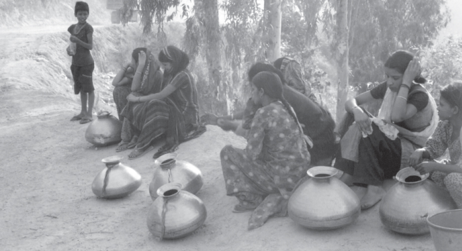

Posted by


